Overblog
Suivre ce blog Administration + Créer mon blog
15 octobre 2015 4 15 /10 /octobre /2015 16:35
ISRO looking to extend GPS services to SAARC countries


Oct 09, 2015 Spacewar.com (IANS)


Bengaluru, India - An ISRO official said on Thursday that they are looking to extend the GPS Aided Geo Augmented Navigation (GAGAN) and Indian Regional Navigation Satellite System (IRNSS) applications to Saarc countries.


"Already we are having within the country the provision for providing the services, we are looking at how we can extend this (navigation services) to Saarc countries in the near future and gradually extending for the entire globe," said A.S. Kiran Kumar, chairman, Indian Space Research Organisation (ISRO), at the second Global Navigation Satellite System (GNSS) User Meet - 2015.


IRNSS applications include terrestrial, aerial and marine navigation, precise timing, disaster management, mapping and geodetic data capture, automated logistics in factories, construction sites and mines, vehicles tracking and fleet management, terrestrial navigation for hikers and travellers and integration with mobile phones.


Surveying emergency response, business solutions, geographical data collection, natural resources, land management, scientific research and geodynamics are some of GAGAN's applications.


"Both GAGAN and IRNSS are certified for operation and this makes India only the fourth country in the world to provide satellite navigation system," said Kumar.


Of the seven satellites of IRNSS constellation, four are already in orbit while the remaining three will be in place by March 2016, Kumar said.


"We have made the signals available from space, what these signals can be used for is only our creative imagination," added Kumar.


As many as 200 receiver systems will be set up incorporating ISRO and industry design for increasing the IRNSS signals, added Kumar.


Lauding ISRO's ability to meet its needs within India, Kumar said that 28 different products were produced within India.

Partager cet article
Repost0
11 septembre 2015 5 11 /09 /septembre /2015 10:25
30-satellite Galileo constellation Credits P. Carril - ESA

30-satellite Galileo constellation Credits P. Carril - ESA


11.09.2015 Romandie.com (ats)


Deux satellites destinés au système européen de navigation Galileo ont été placés en orbite "avec succès" vendredi par le lanceur russe Soyouz, selon Arianespace. Il s'agit du 9e et du 10e satellites de la constellation Galileo, qui doit en compter 30 d'ici 2020.


"La mission a été parfaitement réussie", a déclaré Stéphane Israël, le PDG de la société française Arianespace. "Aujourd'hui, c'est un succès pour Galileo", a-t-il dit depuis le Centre spatial guyanais.

La fusée Soyouz avait décollé du port spatial de l'Europe à Kourou (Guyane française) le 10 septembre à l'heure prévue, à 23h08 heure locale (11 septembre, 04h08 heures suisses). Tout a fonctionné comme prévu et Fregat, l'étage supérieur de la fusée, a largué les satellites sur leur orbite cible, à une altitude proche de 23.500 km, 3 heures et 48 minutes après la mise à feu du lanceur.


Bientôt une couverture mondiale

"Le rythme de déploiement de la constellation Galileo s'accélère", a estimé Jan Woerner, directeur général de l'ESA, cité dans un communiqué. "Avec l'augmentation constante du nombre de satellites en orbite et l'implantation de nouvelles stations au sol dans le monde entier, Galileo aura bientôt une couverture mondiale. Le jour où Galileo atteindra sa capacité opérationnelle complète approche, et ce sera un grand jour pour l'Europe", a-t-il souligné.

Projet emblématique de la Commission européenne, Galileo vise à réduire la dépendance de l'Europe à l'égard du GPS américain, tout en améliorant les services rendus aux utilisateurs grâce à sa très grande précision dans de très nombreux domaines (routier, maritime, agricole, etc). Mais il a essuyé de nombreuses difficultés au fil des ans, accumulant les retards et voyant son coût s'accroître.

Partager cet article
Repost0
30 juillet 2015 4 30 /07 /juillet /2015 11:40
Global Navigation Satellite System (GLONASS)

Global Navigation Satellite System (GLONASS)


Jul 29, 2015 by Sputnik


Moscow - According to a press release from Russian Space Systems, the company has embarked on a new project: the creation of the National High-Precision Satellite Positioning system.


Work is getting underway to create National High-Precision Satellite Positioning system (NSHP), according to the press release by the Russian Space Systems company,which is part of the Russian United Rocket and Space Corporation,the RIA Novosti news agency reported.The project's main goal is to form a high-precision navigation field within Russia.


The NSHP can unite more than 600 GLONASS reference stations, which were the basis for the construction of separate regional high-precision positioning networks, as well as navigation systems of major state and commercial owners. GLONASS is an acronym for the Global Navigation Satellite System, which is operated by the Russian Aerospace Defense Forces and provides an alternative to Global Positioning System, also known as GPS.


Referring to the NSHP, Russian Space Systems said in its press release that "the project will provide decimeter and centimeter accuracy when determining the coordinates of objects in real-time mode".


"The NSVP will provide users with a set of guaranteed positioning services that will be available twenty-four hours a day and seven days a week. The obtained results can be recalculated in line with various systems of coordinates. The NSHP's unique characteristics make it possible to resolve a spate of complex technical problems pertaining to construction, transport and maintenance of infrastructure, land and other fields," the press release said.


According to Russian Space Systems, an increase in the navigation coverage zone will be achieved via the construction of new and optimization of existing navigation networks.


Already signaling their interest in using the NSHP potential are Russia's Novosibirsk, Krasnoyarsk, Yaroslavl, Vologda, Kursk, Omsk and Tyumen Regions, as well as the Yamalo-Nenets Autonomous District and Russia's Republic of Tatarstan have already signaled their interest in using the NSHP network.


Officials from Russia's Siberian Federal District have in turn confirmed their readiness to coordinate and consolidate resources for the joint implementation of the NSHP segment in their district under the auspices of the Plenipotentiary Representative of the Russian President.

Partager cet article
Repost0
6 juillet 2015 1 06 /07 /juillet /2015 07:35
China's Beidou navigation system more resistant to jamming


Jul 01, 2015 Spacewar.com (XNA)


Beijing - China has made breakthroughs in the anti-jamming capability of its Beidou satellite navigation system (BDS), the People's Liberation Army (PLA) Daily said Thursday.


The new technology, developed by Wang Feixue and his team from the National University of Defense Technology, has made the satellites 1,000 times more secure, the newspaper said.


In March, China launched the 17th BDS satellite, the first step in expanding the regional system to a global one.


The first BDS satellite was launched in 2000 to provide an alternative to foreign satellite navigation systems. In December 2012, the system began to provide positioning, navigation, timing and short message services to China and some parts of the Asia Pacific.


The BDS global network will have 35 satellites, five of which will be in geostationary orbit. The complete network should be installed by 2020.

Partager cet article
Repost0
3 juin 2015 3 03 /06 /juin /2015 16:40
The Curse Of GLONASS


May 28, 2015: Strategy Page


A recent cell phone photo from inside a Russian Su-24 fighter cockpit was meant to show the fighter refueling with a Russian Il-76 aerial tanker. But it also showed an American commercial (Garmin) handheld GPS device sitting in handmade cradle placed in front of the pilot. Such improvised GPS receivers were common in Western warplanes in the late 1990s, before they all got GPS built into their navigation systems. Russia has not been able to upgrade the navigation systems on all their older aircraft and improvisations like this are allowed, but not officially publicized.


The Russian Air Force is adapting as best it can to two decades of sharply reduced budgets. That means the elderly Su-24 (first introduced in the mid-1970s) has had to wait longer than expected for a replacement. So far Russia has only been able to buy 60 of the new Su-34 light bombers to replace the Su-24. The Su-34 had its first flight in 1990 and finally entered service in early 2014. While most nations using Su-24s have retired them by now mainly because it was so expensive to operate and maintain them. With all the budget shortages the Russians improvised, because even the refurbished Su-24s usually lacked built in satellite navigation devices. That’s because Russia wanted its air force to have its forces use a Russian built satellite navigation system. This is called GLONASS and without much publicity was Russia was quick to copy the American GPS system even before the Cold War ended and the Soviet Union collapsed in 1991.


GLONASS was at full strength (24 satellites) in 1995. But the end of the Cold War meant the end of the regular financing for GLONASS. Maintaining the system required launching replacement satellites every 5-7 years. With no money that was not possible and by the end of 2002 only seven GLONASS birds were still operational. However, the Russian economy recovered at about the same time. This made possible rebuilding the GLONASS network. By the end of 2007 there were 18 GLONASS satellites active. Russia had 24 GLONASS satellites in orbit by 2011, and the system was fully operational in 2012. It is widely used in Russia and most smart phones adapted for the Russian market have GLONASS.


The money for GLONASS is coming from a Russian government that does not want to be dependent on the American controlled GPS system. But the money is only there because of high oil prices. Most GLONASS receivers in use are actually combined GPS/GLONASS receivers. Russia has put billions of dollars into GLONASS since 2012 to keep the system fully operational. The problem now is money, because of the lower oil prices and growing economic sanctions there may not be enough money to maintain the satellite network. GLONASS will be probably be declared an essential system and the money found. But something will have to be sacrificed and new aircraft for the Russian Air Force is more vulnerable to cuts than GLONASS.

Partager cet article
Repost0
30 mars 2015 1 30 /03 /mars /2015 17:50
Galileo satellites 7 & 8 were enclosed within their protective Soyuz fairing on Friday, 20 March 2015 Credits ESA-CNES-ARIANESPACE

Galileo satellites 7 & 8 were enclosed within their protective Soyuz fairing on Friday, 20 March 2015 Credits ESA-CNES-ARIANESPACE


28 March 2015 by ESA


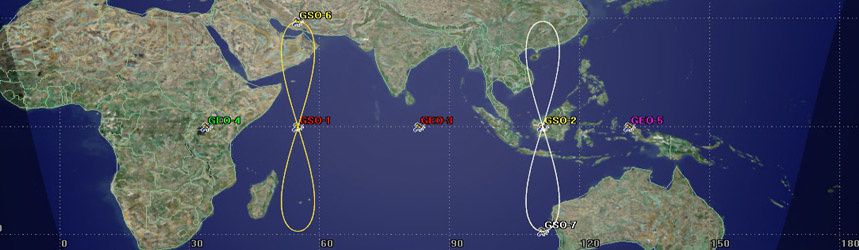
The EU’s Galileo satellite navigation system now has eight satellites in orbit following the launch of the latest pair. 


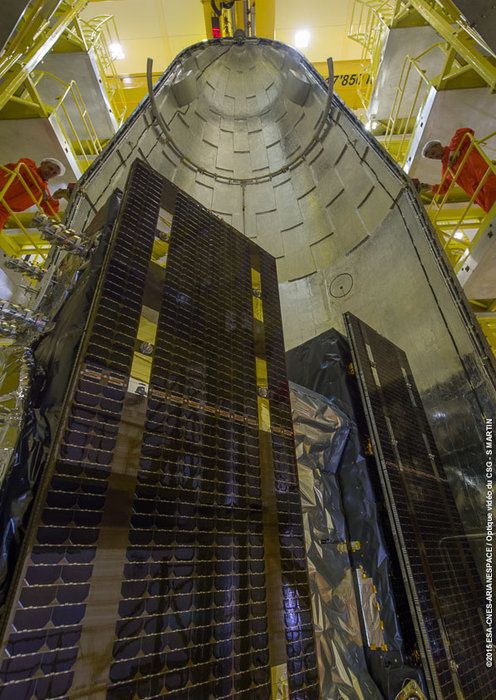
Galileo 7 & 8 lifted off at 21:46 GMT (22:46 CET, 18:46 local time) on 27 March from Europe’s Spaceport in French Guiana on top of a Soyuz rocket.

All the Soyuz stages performed as planned, with the Fregat upper stage releasing the satellites into their target orbit close to 23 500 km altitude, around 3 hours 48 minutes after liftoff.

Following initial checks, run jointly by ESA and France’s CNES space agency from the CNES Toulouse centre, the two satellites will be handed over to the Galileo Control Centre in Oberpfaffenhofen, Germany and the Galileo in-orbit testing facility in Redu, Belgium for testing before they are commissioned for operational service. This is expected in mid-year.

The new pair will join the six satellites already launched, in October 2011, October 2012 and August 2014.

“The deployment of the Galileo constellation is restarting with this successful launch,” said Jean-Jacques Dordain, Director General of ESA.

“The tests in orbit of satellites 5 and 6 have demonstrated the quality and performance of the satellites, and the production of the following ones is well on track. Good news for Galileo.”

Four more satellites are in testing or final integration and scheduled for launch later this year. 

“With six new satellites expected to be in orbit by year’s end, we are now approaching the cruise mode of production, testing and deployment of the satellite constellation,” said ESA’s Director of Galileo and Navigation-related Activities, Didier Faivre.

As set by the European Commission, the objective is to deliver a package of Initial Services, including a free Public Service, an encrypted Public Regulated Service and a Search And Rescue function, by 2016, to be transferred to the responsibility of the European Global Navigation Satellite Systems Agency, GSA.

A full system capability that includes an encrypted commercial service benefiting from 24 operational satellites and six spares is expected to be in place by 2020.


About Galileo

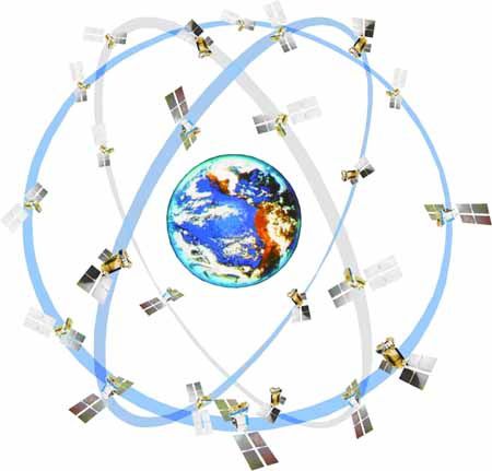
Galileo is the EU’s own global satellite navigation system. It will consist of 30 satellites and their ground infrastructure.

The definition, development and In-Orbit Validation phase were carried out by ESA, and co-funded by ESA and the European Commission. This phase created a mini constellation of four satellites and a reduced ground segment dedicated to validating the overall concept.

The Full Operational Capability phase is fully funded by the European Commission. The Commission and ESA have signed a delegation agreement by which ESA acts as design and procurement agent on behalf of the Commission.

Learn more about Galileo at: http://www.esa.int/Our_Activities/Navigation


About the European Space Agency

The European Space Agency (ESA) provides Europe’s gateway to space.

ESA is an intergovernmental organisation, created in 1975, with the mission to shape the development of Europe’s space capability and ensure that investment in space delivers benefits to the citizens of Europe and the world.

ESA has 20 Member States: Austria, Belgium, the Czech Republic, Denmark, Finland, France, Germany, Greece, Ireland, Italy, Luxembourg, the Netherlands, Norway, Poland, Portugal, Romania, Spain, Sweden, Switzerland and the United Kingdom, of whom 18 are Member States of the EU. Two other Member States of the EU, Hungary and Estonia, have signed Accession Agreements to the ESA Convention and will soon become new ESA Member States.

ESA has established formal cooperation with six Member States of the EU. Canada takes part in some ESA programmes under a Cooperation Agreement.

ESA is also working with the EU on implementing the Galileo and Copernicus programmes.

By coordinating the financial and intellectual resources of its members, ESA can undertake programmes and activities far beyond the scope of any single European country.

ESA develops the launchers, spacecraft and ground facilities needed to keep Europe at the forefront of global space activities.

Today, it develops and launches satellites for Earth observation, navigation, telecommunications and astronomy, sends probes to the far reaches of the Solar System and cooperates in the human exploration of space.

Learn more about ESA at www.esa.int

Partager cet article
Repost0
21 mars 2015 6 21 /03 /mars /2015 17:40
UIMC has developed equipment for the “soldier of the future” combat system


March 19, 2015 by Rostec


The new developments include communication, data transmission, and navigation equipment


United Instrument Manufacturing Corporation (UIMC), which is part of Rostec Corporation, will deliver a new modification of the universal portable kits for soldiers (UPKS) to the ground troops of the Russian Army this year. The kits include communication, data transmission, and navigation systems that enable each individual soldier to operate in a united and automatically managed combat system.


The universal kit for soldiers will help automatize the management of motorized infantry units at the platoon, company, and division levels while also integrating soldiers into a united and automatically managed combat control system. The kit’s components allow soldiers to communicate clearly in navigating terrain, as well as to generate, transmit, and receive data on tactical situations.


The UPKS includes an improved portable radio, subscriber communications device, and tactical terminal. The radio can receive and transmit both audio and data over a distance of up to 5 km through two radio networks (unit and commander). The tactical terminal and subscriber communications device facilitate automatized control, communications, and situational awareness.


The equipment enables soldiers to work in local management and data exchange networks, integrates with GLONASS/GPS navigation systems, provides access to the radio interface of fighting vehicles, and facilitates connectivity to various observation and intelligence resources, including reconnaissance drones. All communications channels in the updated modifications are protected by encryption.


“Today, high-tech components are mandatory elements of combat equipment, including radio communication, navigation devices, handheld computers, software that allows connectivity to databases, electronic cards, and the ability to solve applied problems on a tactical level. UPKS meet all of these requirements,” said Tatiana Ositskaya, chief designer of the kit.


According to her, using the kit will greatly simplify the decision-making process during combat conditions. For example, targeting takes only 30 seconds, the time it required between detecting a target and transferring its coordinates to the necessary weapon for firing.


The kit components are secured on a standard military vest. Downloading additional software modules can expand and supplement the functionality of the kid without changing its components.

Partager cet article
Repost0
20 mars 2015 5 20 /03 /mars /2015 17:20
Rockwell Collins providing secure GPS receivers for Harris tactical radios

Harris Corporation's Falcon III radios will soon be equipped with secure GPS receivers from Rockwell Collins. Photo: Harris Corporation


CEDAR RAPIDS, Iowa, March 19 By Richard Tomkins  (UPI)


Secure, jam-resistant GPS receivers for tactical radios are being provided to Harris Corporation by Rockkwell Collins. Rockwell Collins said Harris has ordered 5,000 of its MicroGRAM system, the largest annual purchase it has received for the system. The Micrograms are being delivered over a period of three years. "MicroGRAM enables Harris Corporation to meet military customer demands for embedded, secure GPS," said Mike Jones, vice president and general manager of Communication and Navigation Products for Rockwell Collins. "MicroGRAM protects warfighters from the growing jamming and spoofing threats on the battlefield, while enhancing survivability and mission success."


Read more

Partager cet article
Repost0
5 mars 2015 4 05 /03 /mars /2015 17:30
Navigating All the Way to Destination


05.03.2015 David Greenwald - Eden Sharon -IAF


An advanced GPS system, which allows accurate navigation of airdrop equipment to ground forces, will soon enter IAF service


The system consists of a parachute, GPS device and the airdrop equipment, can navigate supply in the weight of up to one 1 ton to a pre-set destination. The mission is pre-planned by a computer and the system can also be controlled by a remote control which allows piloting and tracking of the cargo.


With the system it will be possible to track the exact location of the cargo while in air, perform location adjustments or even set up a new destination point. The engineers of the IAF Flight Test Center are now conducting final inspections prior to the system's operational activation.

The testers examine the factors that can affect the ability of the cargo to reach the pre-determined destination: preferable altitudes for airdrop, weight limits and the effect of strong winds on performances.


"This system has an utmost operational value. It will allow airdropping equipment and food from much higher altitudes, an ability which will improve the stealth capabilities of the cargo plane and the accuracy of the parachuting", says Lieutenant Y, an engineer from the IAF Flight Test Center, in charge of the tests. "We expect a correlation between the defined waypoint and the results in the field without any particular difficulties".

Partager cet article
Repost0
29 janvier 2015 4 29 /01 /janvier /2015 08:50
Galileo : les lancements de satellite vont pouvoir reprendre


28.01.2015 Le Monde.fr (AFP)


La Commission européenne a donné, mercredi 28 janvier, son accord à la reprise de lancements de satellite du GPS européen, Galileo (Global Positioning System, système de localisation mondial). Le prochain tir est prévu à la fin de mars sur une fusée Soyouz, a annoncé la société Arianespace. « Nous sommes prêts pour un lancement le 26 mars », a précisé Stéphane Israël, président-directeur général de cette société chargée des lancements. « Je suis déterminée à remettre le programme Galileo sur les rails, a de son côté déclaré la commissaire européenne chargée du marché intérieur et de l'industrie, Elzbieta Bienkowska, lors d'un discours prononcé à la 7e Conférence annuelle européenne sur l'Espace à Bruxelles.


Suite de l’article

Partager cet article
Repost0
16 septembre 2014 2 16 /09 /septembre /2014 11:50
Thales Alenia Space signs new EGNOS framework contract with ESA
 
September 12, 2014 Thales Group
 

Cannes, September 12th, 2014 – Thales Alenia Space announced today that it has signed a new framework contract with the European Space Agency (ESA) concerning the EGNOS navigation system. The contract will enable ESA, delegated by the European Commission, to order work packages from Thales Alenia Space France for the period 2014-2017, to develop new versions of EGNOS V2. Designed to ensure the continuous improvement of EGNOS performance, these new versions will guarantee optimum service quality for users, while also addressing the need to manage obsolescence.

Thales Alenia Space is the prime contractor for EGNOS, the European Geostationary Navigation Overlay System, which is designed to improve the positioning signals delivered by the GPS satellite navigation system. EGNOS was deployed starting in 2005, and has been operational since 2009, for open service. The system's "Safety of Life" service was officially declared operational in March 2011, and allows it to be used for aircraft landing, enabling precision approaches to European airports without ground guidance aids.

"The signature of this framework contract with ESA, in the presence of GSA*, marks a decisive new step for Europe's EGNOS navigation system," noted Philippe Blatt, head of the Navigation business line at Thales Alenia Space France. "We are already prime contractor for the Galileo Mission Segment (GMS), the Galileo Security Facility (GSF) and the Galileo system. This latest contract confirms Thales Alenia Space's position as the European leader in satellite navigation, a position we have held for over 20 years."


* GSA: European GNSS Agency


About Thales Alenia Space

Thales Alenia Space, a joint venture between Thales (67%) and Finmeccanica (33%), is a key European player in space telecommunications, navigation, Earth observation, exploration and orbital infrastructures. Thales Alenia Space and Telespazio form the two parent companies' “Space Alliance”, which offers a complete range of services and solutions. Because of its unrivaled expertise in dual (civil/military) missions, constellations, flexible payloads, altimetry, meteorology and high-resolution optical and radar instruments, Thales Alenia Space is the natural partner to countries that want to expand their space program. The company posted consolidated revenues in excess of 2 billion euros in 2013, and has 7,500 employees in six countries. www.thalesaleniaspace.com

Partager cet article
Repost0
5 décembre 2013 4 05 /12 /décembre /2013 08:50
Galileo progresse avec l'École Royale Militaire (ERM)


02/12/13 Laurence Gastout –MIL.be


Perdu sur la route ? Pour bon nombre d'entre nous, le réflexe est de brancher son navigateur GPS ou de consulter Google Maps sur son smartphone. Parmi les outils à utilisation militaire, on retrouve également le système américain GPS. Mais l'Europe n'est pas en reste et développe également son système de géolocalisation Galileo. À cette fin, le Professeur Muls et deux étudiants de l'École Royale Militaire (ERM) mettent la main à la pâte.


Actuellement, ce sont les États-Unis qui détiennent le monopole du système de positionnement par satellite. « Etant membre de l'OTAN, la Belgique utilise le service militaire crypté du GPS en opération », explique le Professeur Alain Muls, directeur du département de Communication, Information, Systems & Sensors (CISS) de l'ERM. « Le projet Galileo permettra à l'Europe de disposer d'un système de navigation en gestion propre, d'offrir un service de navigation crypté pour une utilisation gouvernementale et profitera aussi de l'essor économique engendré par ces systèmes de géolocalisation. »


Outre ces avantages, Galileo présente une modernisation technologique par rapport au GPS actuel. En effet, actuellement les services de navigation se basent sur des signaux et une technologie des années '70 tandis que Galileo se structure sur des signaux plus récents et plus performants. Cela permettra, en temps réel, une précision se rapprochant du mètre.


Le Professeur Muls s'intéresse plus particulièrement au Public Regulated Service (PRS) de Galileo. « En d'autres termes : le service de navigation basé sur des signaux cryptés et qui sera réservé à des organismes gouvernementaux comme la Défense, les ministères fédéraux ou encore les services de secours », commente Alain Muls.


En décembre, des prototypes de récepteur des signaux Galileo PRS prendront le large sur notre frégate Léopold I en direction de la Norvège. L'objectif étant de tester la sensibilité, la robustesse et la précision du PRS en se rapprochant du cercle polaire. La mise en place et le câblage ont été préparés par l'unité Naval Logistics and Maintenance de Zeebruges.

Partager cet article
Repost0
22 novembre 2013 5 22 /11 /novembre /2013 17:20
Lockheed Martin’s GPS III satellite prototype passes backward-compatibility tests

GPS III Nonflight Satellite Testbed (GNST)at Cape Canaveral Air Force Station, US. Photo Lockheed Martin


22 November 2013 aerospace-technology.com


Lockheed Martin has announced its prototype of the next-generation global positioning system (GPS) satellite, the GPS III, has completed successful testing for backward-compatibility with the previous GPS satellite constellation in orbit.


The GPS III Nonflight Satellite Testbed (GNST), a full-sized, functional satellite prototype, is currently at Cape Canaveral Air Force Station in the US.


During the trials in October, GNST was successful in communicating through cross-links with air force flight-like hardware simulators for the GPS IIR, GPS IIR-M, and GPS IIF satellites in orbit.


This testing also showed the ability of an air force receiver to track navigation signals from the GNST.


Lockheed Martin GPS III development director Paul Miller said: "This provides early confidence in the GPS III's design to bring advanced capabilities to our nation, while also being backward-compatible."


A vital programme for the air force, GPS III is a cost-effective solution for ageing GPS satellites in orbit, and will improve ability to address the growing demands of military, commercial and civilian users.


According to Lockheed Martin, GPS III satellites will offer three times improved accuracy and up to eight times more powerful anti-jamming capabilities, and include enhancements to extend spacecraft life by 25%, compared with the existing GPS block.


In addition, it will be the first GPS satellite featuring a new L1C civil signal created to make it interoperable with other global navigation satellite systems.


Lockheed Martin is currently under contract to produce the first four GPS III satellites (SV 01-04), and has secured advanced procurement funding for long-lead components for the fifth, sixth, seventh, and eighth satellites (SV 05-08).


The first flight-ready GPS III satellite is expected to arrive at Cape Canaveral next year, with launch scheduled by the air force for 2015.


The GNST arrived at the air force station in July to test facilities and pre-launch processes.


On 30 August, the satellite prototype successfully established remote connectivity and communicated with the GPS next-generation operational control system (OCX) that is being developed by Raytheon.

Partager cet article
Repost0
19 novembre 2013 2 19 /11 /novembre /2013 08:40
Les USA refusent d'installer des stations terrestres GLONASS


MOSCOU, 18 novembre - RIA Novosti


Le Pentagone et la CIA tentent d’empêcher l’installation du système de navigation satellite russe GLONASS sur le territoire américain, écrit lundi 18 novembre le quotidien Novye Izvestia citant le New York Times.


L'armée et les renseignements craignent que le Kremlin puisse utiliser ces stations à des fins militaires, notamment pour accroître la précision du guidage des missiles par satellite. De plus, les renseignements américains pensent que les stations GLONASS permettraient à Moscou d'espionner plus facilement les USA.


Les experts estiment que cette initiative des "chevaliers de cap et d'épée" américains vise simplement à empêcher la Russie d’arriver sur le marché mondial de la navigation par satellite. Mais en comparaison avec la menace transatlantique, il existe des risques bien plus graves pour GLONASS en raison de la corruption en Russie et de l'opposition des automobilistes.


Selon les hauts fonctionnaires russes, la nécessité actuelle de mettre en place des stations terrestres dans le cadre du programme GLONASS est due au déploiement plus tardif du système russe par rapport à son concurrent américain GPS, qui est presque deux fois plus précis pour déterminer les coordonnées.


Ce n’est pas négligeable : il s'agit ici du partage du marché mondial de la navigation par satellite qui, selon les experts, doublera d'ici la fin de la décennie pour atteindre 165 milliards d'euros. L'agence spatiale russe Roskosmos a donc décidé d'améliorer la précision des données spatiales depuis le sol.


Dans ce sens la Russie a commencé d’installer des stations terrestres à l'étranger. La première a été mise en place et fonctionne correctement en Antarctique à la station Bellingshausen.


Une autre a été installée au Brésil. Deux autres stations devraient être construites prochainement dans ce pays. D'ici quelques années des stations supplémentaires seront déployées à Cuba, au Vietnam et en Australie. Cependant, la décision de mettre en place une station aux USA a rencontré une certaine résistance.


"Les accusations d'espionnage sont un élément de lutte non concurrentiel pour un marché de dizaines de milliards d'euros disputé par les USA et la Russie, déclare Igor Korotchenko, directeur du Centre d'analyse du commerce mondial des armements. Les deux pays ont l'intention de promouvoir des services de navigation par satellite aux consommateurs, sachant que GLONASS représente une concurrence montante pour les Américains. Evidemment, personne n'interdira le GPS en Russie car cela entraînerait une baisse de la sécurité des transports et de l'efficacité des compagnies de transport. Mais les USA pourraient réduire la précision des coordonnées ou même débrancher les utilisateurs de GPS en Russie en cas de besoin."


Par ailleurs, le lancement du système GLONASS dans le civil ne se fait pas sans accroc. Les conducteurs de taxis collectifs et de diverses compagnies de transport, qui installent des émetteurs GPS/GLONASS sous la pression des autorités et à la recherche du profit (le contrôle spatial de la circulation des moyens de transports permet de faire d'importantes économies sur le carburant, la logistique et permet à la direction d'une compagnie de suivre ses conducteurs en temps réel), sont opposés à cette innovation. Alexandre Smirnov, responsable du département des ventes d'une compagnie intégrant le GLONASS, explique que les conducteurs ont trouvé trois moyens pour lutter contre les navigateurs – les casser avec une masse, ouvrir le sceau ou acheter des brouilleurs chinois.

Partager cet article
Repost0
30 septembre 2013 1 30 /09 /septembre /2013 17:50
Thales Alenia Space signs contract for EGNOS services worth more than 120 million euros

Sep 27, 2013 ASDNews Source : Thales Group


Thales Alenia Space today announced the signature of a contract with Telespazio worth more than 120 million euros, within the scope of a contract for the supply of EGNOS services (European Geostationary Navigation Overlay Service), signed by ESSP (European Satellite Services Provider) and Telespazio in July 2013. The overall contract covers EGNOS support and maintenance operations for a period of eight years. As the lead program partner, Thales Alenia Space is responsible for EGNOS maintenance, including obsolescence management and minor upgrades. The aim is to guarantee an optimized service level, as well as to integrate new EGNOS system functions especially for aviation and maritime transport applications.


EGNOS, the European Geostationary Navigation Overlay System, is designed to improve the positioning messages supplied by GPS (Global Positioning System). Thales Alenia Space is the EGNOS prime contractor. EGNOS was deployed starting in 2005, and has been operational in "open service" since 2009. The system's "Safety of Life" service was officially declared operational in March 2011, and enables its use in the aviation sector for landings, as well as precision approaches to European airports, without requiring ground guidance systems.


Read more

Partager cet article
Repost0
12 juillet 2013 5 12 /07 /juillet /2013 07:40
L'explosion de la fusée russe provoquée par des capteurs montés à l'envers

11/07/2013 Par Cyrille Vanlerberghe – LeFigaro.fr


Un lanceur russe Proton-M s'est écrasé au sol la semaine dernière à cause d'une erreur grossière d'assemblage dans une usine à Moscou.


Le 2 juillet dernier sur le cosmodrome de Baïkonour au Kazakhstan, le vol de la fusée Proton-M qui emportait trois satellites Glonass, le «GPS» des forces armées russes, a été de très courte durée. Quelques secondes après son décollage, le lanceur a commencé à dévier de sa trajectoire verticale, s'est élevé en s'inclinant sur le côté avant de plonger vers le sol et d'exploser en une immense boule de feu à un kilomètre du pas de tir. Le coût cumulé du lanceur et des trois satellites militaires est estimé à 200 millions de dollars, d'après l'agence Reuters.


L'enquête menée par les experts de l'agence spatiale russe Roskosmos a rapidement trouvé les causes de l'accident, révèle le site Russian Space Web. À partir de l'analyse de la télémétrie du vol, ils ont pu établir que la fusée avait décollé quatre dixièmes de seconde avant l'instant prévu, ce qui fait qu'elle avait quitté le pas de tir avec des moteurs qui ne fonctionnaient pas encore à pleine puissance. Cette anomalie a déclenché un programme de vol qui a poussé les moteurs à fond pour tenter d'éloigner le lanceur du pas de tir. L'augmentation brutale de la puissance a provoqué un début d'incendie sur l'un des six moteurs du premier étage, qui a été arrêté automatiquement au bout de quatre secondes. Le décollage prématuré a apparemment été provoqué par la rupture accidentelle des câbles reliant les équipements au sol au bas du lanceur.


L'arrêt d'un des moteurs a pu déséquilibrer le lanceur dans sa phase d'ascension, mais cela ne suffit pas à expliquer pourquoi il est parti violemment dans tous les sens avant de foncer vers le sol. Le 9 juillet, les enquêteurs ont finalement résolu le mystère en retrouvant près du cratère laissé par l'impact des capteurs d'accélération montés dans le mauvais sens.


Une erreur d'assemblage grossière


Des flèches sont inscrites sur les boîtiers pour indiquer le haut du véhicule, mais trois d'entre eux, contrôlant la direction de la trajectoire, étaient montés avec la flèche vers le bas. Le système de contrôle du Proton recevait donc des informations fausses lui indiquant qu'il fonçait vers le bas, et a donc tenté d'inverser brutalement sa trajectoire.


Cette erreur d'assemblage est d'autant plus incroyable qu'il faut fournir «une force physique considérable» pour réussir à installer les capteurs sens dessus dessous, explique Anatoly Zak, expert du spatial russe et auteur du site Russian Space Web. La faute n'a pas été détectée lors des tests à l'usine d'assemblage de Khrounitchev à Moscou, qui se vante pourtant d'un label de contrôle qualité ISO 9001, mais elle est également passée inaperçue dans le bâtiment d'assemblage de Baïkonour.


Les lancements de fusées Proton sont suspendus jusqu'à nouvel ordre, ce qui retardera inévitablement la mise en orbite de plusieurs satellites commerciaux de télécommunications, secteur sur lequel Proton est l'un des plus sérieux concurrents des Ariane 5 européennes.

Partager cet article
Repost0
11 juillet 2013 4 11 /07 /juillet /2013 16:20
M982 Excalibur round photo USMC

M982 Excalibur round photo USMC

July 11, 2013: Strategy Page


The U.S. Army has found that GPS guided shells were more successful, but less frequently used, than anticipated. So they reduced orders for these weapons, which entered service in 2007. The GPS guided 155mm Excalibur shells were used less frequently largely because other precision munitions often take out targets before Excalibur gets a chance to. There’s a growing number of other GPS (or laser) guided weapons available.  The GPS guided MLRS (GMLRS) rocket has been especially popular. And the army uses a lot of laser guided Hellfire missiles, fired from AH-64 helicopter gunships. In addition to the reduction in Excalibur production, the army cut orders for GPS guided 120mm mortar shells (introduced in 2011) after a year of use.


Excalibur had other problems, mainly in the form of PGK (Projectile Guidance Kit) shells. PGK is actually a large fuze, that screws into the front of a 155mm or 105mm shell. This longer fuze contains a GPS and small fins to guide the shell to a precision hit. It is less precise than Excalibur. That is, the PGK will ensure that the shell lands within 50 meters of the target. If it does not hit within 150 meters, PGK deactivates and the shell does not explode. An unguided shell will normally land within 250-300 meters of where it is aimed. An Excalibur shell lands within four meters of the target, but costs more than twice as much as PGK. The army recently sent the first PGKs to Afghanistan, after successful testing in the United States. The big question is how important will the troops find the accuracy differences of Excalibur and PGK.


Another factor that hurt the popularity of Excalibur, and the 120mm guided mortar shell, is cost. Excalibur was supposed to cost about $50,000 each. Eventually. After all the debugging, and after more of the shells were produced. But the cost is still about $100,000 per shell. The 120mm GPS (using the same tech as PGK) guided shell is also pricey, but not as much as Excalibur. GMLRS cost about $100,000 each, and have a much longer range, and a bigger bang.


Another edge GMLRS has is the HIMARS rocket launcher. Only costing about $3 million each, these smaller, truck mounted MLRS (HIMARS) rocket launcher systems have become very popular. HIMARS carries only one, six MLRS rocket, container (instead of two in the original MLRS vehicle). But the 12 ton truck can fit into a C-130 transport (unlike the 22 ton tracked MLRS) and is much cheaper to operate. The first HIMARS entered service in 2005, about a year after GPS guided rockets did.


The 309 kg (680 pound) GMLRS (guided multiple launch rocket system) missile is a GPS guided 227mm rocket. It was designed to have a range of 70 kilometers and the ability to land within meters of its intended target, at any range. This is possible because it uses GPS (plus a back-up inertial guidance system) to find its target. In 2008 the army tested GMLRS at max range (about 85 kilometers) and found that it worked fine. This enabled one HIMARS vehicle to provide support over a frontage of 170 kilometers, or, in places like Afghanistan, where the fighting can be anywhere, an area of over 20,000 square kilometers. This is a huge footprint for a single weapon (an individual HIMARS vehicle), and fundamentally changes the way you deploy artillery in combat. Excalibur has a max range of 37 kilometers, and 120mm mortars about 7.5 kilometers.


The U.S. Army is buying over 800 HIMARS vehicles along with 100,000 GMLRS rockets, most of them fitted with an 89 kg (196 pound) high explosive warhead. About half of that is actual explosives. These have been used with great success in Iraq and Afghanistan, where nearly two thousand have been fired so far. The guided rocket is much more effective than the older, unguided, version, and is replacing it in most cases. No more of the unguided rockets are being purchased by the U.S.. The accuracy of GMLRS means that one rocket does the job that previously required a dozen or more of the unguided ones. That's why HIMARS is so popular. While it only carries six rockets, that's often enough to last for days, even when there's a lot of combat.


The 120mm mortar round has about 2.2 kg (five pounds) of explosives, compared to 6.6 kg (15) pounds in a 155mm shell. The smaller explosive charges limits collateral damage to civilians. But in Afghanistan, it is more common to need a large bang (which GMLRS can deliver). Excalibur was more suited to Iraq, but the American troops have left there, and all the action is in Afghanistan. Moreover, there are a lot of precision weapons readily available to the infantry that have small warheads. The Javelin missile has a 4 kg (nine pound) warhead, and the larger TOW has a 5.9 kg (13 pound one.) The Hellfire missile has a 9 kg/20 pound warhead. The air force also has its SDB (114 kg/250 pound small diameter bomb, carrying 23 kg/51 pounds of explosives.).


Meanwhile, there is still demand for unguided 155mm and 120mm shells. There are times when you need firepower over a large area (several hundred meters by several hundred meters), and for this, unguided shells do the job best, and cheapest.


In response to this competition the Excalibur manufacturer has created a model that can be used in 127mm naval guns. These are found in hundreds of warships and enable these ships to use their 127mm guns to accurately hit targets over 40 kilometers inland.

Partager cet article
Repost0

Présentation

  • : RP Defense
  • : Web review defence industry - Revue du web industrie de défense - company information - news in France, Europe and elsewhere ...
  • Contact

Recherche

Articles Récents

Categories