Overblog
Suivre ce blog Administration + Créer mon blog
30 octobre 2012 2 30 /10 /octobre /2012 11:50

Bouclier missile source Ria Novisti


Oct 30, 2012 (Voice of Russia)


Moscow - Russian Aerospace Defense forces have successfully launched a short-range missile as part of the country's missile shield test, Space Forces spokesman Colonel Alexei Zolotukhin told reporters Tuesday.


He said a missile crew of the Sary-Shagan test site together with space forces and some defense industry representatives successfully conducted a launch of a short-range anti-missile rocket at 12.01 a.m. Moscow time.


Pantsyr-S shoots down cruise missile

The Russian armed forces have successfully carried out live firing tests of the Army's Pantsyr-S short-range gun-missile air defense system against cruise missile targets for the first time at the Pemboi range in the country's northern Komi republic.


The system had previously only been tested against practice targets imitating cruise missiles.


Cruise missiles represent a difficult target as they are small, fast-moving, can fly at very low levels and often have a low infrared and radar signature.


The Pantsyr can engage targets up to 20 km by missile and 4 km using the cannon.


US ABMs spreading in Asia - Panetta

The US will continue building a global missile "defense" system and its related facilities in Asia, including in South Korea according to an official statement by Pentagon chief Leon Panetta.


"The Republic of Korea and the US are continuing their dialogue on missile defense" Panetta said, adding that the US and South Korea have agreed to continue their "close observation" of North Korea and plan to avert all provocations by North Korea.


There are nearly 70 American nuclear bombs in Turkey

There are nearly 70 American B61 nuclear bombs in Turkey. All of them are deployed on the Turkish Incirlik Air Base, Adana.


Despite the factual presence of the US air bombs, the possibilities of using them are limited, the Haberturk Agency reported.


The greater part of these bombs is the property of the U.S. army, and Washington reserves the right to use them in case of need. Until 1995 from 10 to 20 B61 bombs were deployed on the two other air bases in the country but later all of them were transferred to the Incirlik Air Base.

Partager cet article
Repost0
30 octobre 2012 2 30 /10 /octobre /2012 11:45

National Emblem of the People's Republic of China.svg


Oct 29, 2012 (XNA)


Beijing - Chinese Defense Ministry spokesman Yang Yujun has dismissed media reports about a planned test launch of an anti-satellite missile in November.


"Such reports did not conform to the fact," Yang said at a regular news briefing on Thursday.


Reports said that China will conduct the test targeting satellites with a high orbit altitude, such as reconnaissance satellites and navigation satellites.


Reports said the test would be conducted after the U.S. presidential election next month.

Partager cet article
Repost0
29 octobre 2012 1 29 /10 /octobre /2012 18:35

http://www.defense.gouv.fr/var/dicod/storage/images/base-de-medias/images/air/actualites/images-2012/images-octobre-2012/l-antenne-orfees-est-implantee-a-la-station-de-radioastronomie-de-nancay/2052351-1-fre-FR/l-antenne-orfees-est-implantee-a-la-station-de-radioastronomie-de-nancay.jpg

L'antenne ORFEES est implantée à la station de

radioastronomie de Nançay


29/10/2012 Slt Alexandra Lesur-Tambuté - Economie et technologie


Depuis le 22 octobre 2012, la campagne de validation opérationnelle du projet FEDOME (fédération des données de météorologie de l’espace) a commencé.


Le projet FEDOME a été initié par l’adjudant Lionel Birée, de la division surveillance de l’espace (DSE) du commandement de la défense aérienne et des opérations aériennes.  Financé par la mission pour le développement et l’innovation participative de la direction générale pour l’armement, il a pour objectif de démontrer la faisabilité et l’intérêt d’un service d’alerte opérationnel des événements météorologiques de l’espace au profit des unités de la Défense. Afin d’alimenter la base de données du serveur FEDOME, la DSE s’appuie sur deux capteurs : la station SID (Sudden Ionospheric Disturbance - perturbation ionosphérique soudaine) et l’antenne ORFEES (observation radio spectrographique pour FEDOME et les études des éruptions solaires), instrument principal d’alerte en cours de validation. 


Implantée à la station de radioastronomie de Nançay, l’antenne ORFEES est une copropriété de l’armée de l’air et de l’observatoire de Paris. Elle observe quotidiennement les émissions radioélectriques du soleil. Ses relevés ont pour objectifs de déterminer si les éruptions solaires sont une menace et donnent l’opportunité de détecter la présence de particules néfastes pour les communications (transmission radio, navigation GPS) des aéronefs de l’armée de l’air. «Avec cette phase de validation opérationnelle, nous souhaitons prouver que les données de l’antenne ORFEESsont bien capables d’aider les unités navigantes à gérer leurs fréquences», explique l’adjudant Birée.


Actuellement, lorsqu’un E-3F part en mission, le centre national des opérations aériennes (CNOA) fournit à l’équipage des blocs de fréquence en HF. Pour cela, le CNOA utilise un logiciel de propagation des ondes qui ne prend pas en compte l’activité solaire. Si l’avion se trouve dans une zone concernée par une éruption solaire, ses fréquences risquent d’être saturées. L’équipage de l’E-3F doit alors chercher d’autres fréquences. «Avec les alertes fournies par le serveur FEDOME (qui enregistre les données des antennes SID et ORFEES), nous éviterons cette perte de temps en prévoyant les fréquences à utiliser en fonction du trajet de l’aéronef et des perturbations encourues», ajoute l’adjudant.


Pendant six mois, la DSE émettra des messages d’alerte au profit du centre météorologique des opérations aériennes, du centre national des opérations aériennes ou encore du commandement des forces aériennes stratégiques. Les unités mobilisées dans cette étude utiliseront ces données à chaque mission ou entrainement. À la fin de la période de test, ils réaliseront alors des retours d’expériences déterminantes dans la validation du projet.


Cette optimisation de gestion des fréquences serait unique en Europe. ORFEES confirmerait alors le nouveau pas déjà bien engagé d’un service d’alerte et de météo de l’espace dans le cadre du projet FEDOME, mené conjointement avec des organismes civils.


http://www.defense.gouv.fr/var/dicod/storage/images/base-de-medias/images/air/actualites/images-2012/images-octobre-2012/le-serveur-fedome-de-la-division-surveillance-de-l-espace-du-cdaoa-a-paris/2052356-1-fre-FR/le-serveur-fedome-de-la-division-surveillance-de-l-espace-du-cdaoa-a-paris.jpg

Le serveur FEDOME, de la division surveillance de l'espace du CDAOA à Paris


http://www.defense.gouv.fr/var/dicod/storage/images/base-de-medias/images/air/actualites/images-2012/images-octobre-2012/le-serveur-fedome-enregistre-les-donnees-des-antennes-sid-et-orfees/2052361-1-fre-FR/le-serveur-fedome-enregistre-les-donnees-des-antennes-sid-et-orfees.jpg

Le serveur FEDOME enregistre les données des antennes SID et ORFEES

Partager cet article
Repost0
29 octobre 2012 1 29 /10 /octobre /2012 12:45

SBIRS GEO-1 Satellite source Lockheed Martin


SUNNYVALE, Calif., Oct. 26 (UPI)


Initial work on more geosynchronous satellites in the U.S. Air Force's Space Based Infrared System missile warning system has been awarded to Lockheed Martin.


The contract for the initial work on satellites 5 and 6 is worth $82 million.


"This initial contract will sustain a steady production rate and by the Air Force acquiring satellites in bulk, rather than one at a time, we can significantly reduce costs by achieving economies of scale," said Jeff Smith, vice president of Lockheed Martin's Overhead Persistent Infrared mission area.


"We understand both the importance of the SBIRS mission and the weight of the current fiscal environment and we are committed to delivering mission success affordably and efficiently for the Air Force."


SBIRS satellites and payloads, placed in a highly elliptical orbit, deliver improved missile warning and intelligence and battlespace awareness.


Under the contract for first-phase work, Lockheed Martin will complete non-recurring engineering activities for the satellites and procure long-lead spacecraft parts.


Previous SBIRS contracts given to Lockheed have included four payloads, four GEO satellites, and ground systems for processing and disseminating data from the satellites.


The first SBIRS satellite has been launched and the second is to be launched in March.

Partager cet article
Repost0
29 octobre 2012 1 29 /10 /octobre /2012 12:00

beidou-launch-long-march-3c-rocket-xichang-lg.jpg

Long March-3C launch


Oct 29, 2012 (XNA)


Xichang, China - China successfully launched another satellite into space for its indigenous global navigation and positioning network at 11:33 p.m. Beijing Time Thursday, the launch center said.


The satellite, launched from the Xichang Satellite Launch Center in the southwestern province of Sichuan, was boosted by a Long March-3C carrier rocket.


It was the 16th satellite for the Beidou system, or Compass system.


The network is planned to officially provide services for most parts of the Asia-Pacific region in early 2013 and begin offering global services by 2020.


Since it started to provide services on a trial basis on Dec. 27, 2011, the Beidou system has been stable, said a spokesperson of the China Satellite Navigation Office.


The system has been gradually used in extended sectors including transportation, weather forecasting, marine fisheries, forestry, telecommunications, hydrological monitoring and mapping, according to the spokesperson.


The newly-launched satellite will play an important role in improving the system's service, the spokesperson said.


China started to build up its own satellite navigation system to break its dependence on the U.S. Global Positioning System in 2000.


Between October 2000 and May 2003, the country set up a regional satellite navigation system after launching three Beidou geostationary satellites.


Beidou-1 can not meet growing demand, so China decided to set up a more functional Beidou-2 regional and global navigation system, Qi Faren, former chief designer for Shenzhou spaceships, said in an interview in 2011.


The Beidou-2 system will eventually consist of 35 satellites.


Five Beidou satellites were sent into space early this year. The 11th satellite was boosted by a Long March-3C carrier rocket on Feb. 25, the 12th and 13th were sent by a Long March-3B carrier on April 30, while the 14th and 15th satellites were launched on Sept. 19.


Source: Xinhua News Agency

Partager cet article
Repost0
27 octobre 2012 6 27 /10 /octobre /2012 11:35

http://static.progressivemediagroup.com/uploads/imagelibrary/SBIRSGEOS8%20n.jpg


26 October 2012 airforce-technology.com


Lockheed Martin has been awarded a contract to start initial work on the US Air Force's (USAF) fifth and sixth space-based infrared system (SBIRS) geosynchronous earth orbit (GEO) satellites.


Valued at $82m, the initial contract represents the first of three GEO-5 and 6 satellite acquisition phases, and covers completion of non-recurring engineering activities and purchase of select long lead spacecraft parts by the company to help supplier production lines offer the lowest possible price for each component.


Procurement of the remaining long lead parts, as well as satellite production, is scheduled to be subsequently funded by the second and third acquisition phases under a fixed-price contract scheme.


Lockheed Martin Overhead Persistent Infrared (OPIR) mission area vice president Jeff Smith said the contract will support a steady production rate and will significantly reduce the programme costs as the air force is procuring satellites in bulk, as opposed to one at a time.


''We understand both the importance of the SBIRS mission and the weight of the current fiscal environment - and we are committed to delivering mission success affordably and efficiently for the Air Force,'' Smith said.


The SBIRS satellites are designed to provide timely and accurate warning for missile launches to the US government, using a combination of four GEO satellites, two highly elliptical earth (HEO) payloads, as well as related ground hardware and software.


To date, Lockheed has received contracts for production of four HEO payloads, four GEO satellites, as well as ground assets for acquisition, processing and dissemination of the infrared mission data.


The SBIRS GEO-1 was launched by USAF from Cape Canaveral Air Force Station onboard an Atlas V rocket on 7 May 2011, and the GEO-2 is scheduled for launch in March 2013, while the GEO-3 and GEO-4 are currently under various stages of development.

Partager cet article
Repost0
26 octobre 2012 5 26 /10 /octobre /2012 12:05

http://www.astrium-geo.com/files/pmedia/public/r2151_9_soyouz_kourou_els.jpg

source astrium-geo.com


Oct 26, 2012 ASDNews Source : Arianespace


Activities for Arianespace’s fourth medium-lift Soyuz flight from the Spaceport is fully underway as the Pléiades 1B payload has now arrived in French Guiana – joining the mission’s launcher, which is well advanced in its preparations.


The dual-use, very-high-resolution satellite was delivered this week by a Boeing 747 cargo aircraft to Félix Eboué Airport near the capital city of Cayenne, where it was unloaded for transfer by road to the Spaceport.


Pléiades 1B will be orbited on a late-night November 30 flight from the ELS launch complex at the Spaceport, where the basic three-stage Soyuz vehicle already has been built up inside the MIK assembly building.  Elsewhere at the Spaceport, the launcher’s Fregat upper stage is now undergoing its fueling process in the S3B processing building.


The November flight – designated VS04 in Arianespace’s mission numbering system – will mark the fourth Soyuz liftoff from French Guiana since this medium-lift vehicle’s service entry in October 2011.


Its Pléiades 1B payload is designed to provide optical observation coverage with 50-centimeter resolution for the French and Spanish defense ministries, civil institutions, and private users.  Operating from a 695-km. quasi-polar heliosynchronous orbit, it will accompany the twin Pléiades 1A spacecraft launched last December on Arianespace’s VS02 Soyuz mission from the Spaceport.


The Astrium division of EADS built both Pléiades satellites for the French CNES space agency, which is prime contractor and system architect.  They are based on smaller, cheaper, more agile platforms than their predecessors – the highly-successful Spot satellite series, which was launched on Ariane family launchers by Arianespace beginning in 1986.

Partager cet article
Repost0
26 octobre 2012 5 26 /10 /octobre /2012 07:20

National Emblem of the People's Republic of China.svg


2012-10-25 xinhua


Le porte-parole du ministère chinois de la Défense Yang Yujun a rejeté jeudi des informations de médias selon lesquels la Chine aurait envisagé de réaliser un test de lancement d'un missile antisatellite en novembre.


"Ces rapports ne correspondent pas à la réalité", a déclaré M. Yang


Certains médias ont rapporté récemment que la Chine comptait réaliser un test de lancement de missile visant des satellites en orbite à haute altitude, tels que les satellites de détection ou de navigation. Selon ces rapports, ce test serait réalisé après l'élection présidentielle américaine en novembre.

Partager cet article
Repost0
25 octobre 2012 4 25 /10 /octobre /2012 17:20

Galileo.svg


Oct 25, 2012 ASDNews Source : European Space Agency


A helicopter recently flew over a very special Alpine valley to gather data on how Europe’s two satellite navigation systems – EGNOS and Galileo – will work together in future.


The helicopter flew a variety of manoeuvres, from fast loops to mid-air hovering, to see how satnav signals were received in practice. The promising results are now being analysed.


The airborne testing, which took place in Germany on 24–26 September, was based around prototype signals of the next generation of the European Geostationary Navigation Overlay Service – EGNOS – combined with simulated Galileo signals.


EGNOS, the first pan-European satellite navigation system, works by sharpening the accuracy of US GPS signals.


The first four Galileo satellites have been placed in orbit – the minimum needed to provide basic navigational services. It will take many more to provide global coverage.


But there is one place in Europe where full Galileo service coverage is already a reality: the town of Berchtesgaden in the Bavarian Alps has transmitters atop eight neighbouring mountain peaks to blanket 65 sq km of territory with satnav signals.


The result is the Galileo Test and Development Environment – GATE – a giant outdoor laboratory where prototype Galileo receivers can be used freely without any modifications.


Kept busy by European industrial and research teams, GATE is owned by the DLR German Aerospace Center. ESA’s Global Navigation Satellite Systems for Europe (GNSS) Evolution programme uses it to help prepare the design of next-generation systems.


The helicopter testing relied on the SPEED platform – Support Platform for EGNOS Evolutions & Demonstrations – enabling a user to receive simultaneous real-time augmentation signals for both GPS and Galileo, in the same way that the intended next-generation EGNOS system will operate.


Evolving EGNOS


The ESA-designed EGNOS employs a trio of satellites, processing facilities and a network of ground stations to improve the accuracy of GPS satnav signals over European territory.


The service is guaranteed to an extremely high level of reliability set by the International Civil Aviation Organisation: it is allowed just a one in 10 million chance of error.


The satellite-based service provides horizontal and vertical guidance information for aircraft performing safety-critical landing approaches to airports in a similar way to existing Instrument Landing System devices – but with no local ground-based navigation infrastructure needed.


“EGNOS is already certified for European aviation but what we are testing here is how it operates with Galileo,” explained Guenter Hein, head of ESA’s GNSS Evolution programme.


“We are seeking to develop the next generation of EGNOS, which should be ready and operational around 2020.


“The ambition for Europe is to have an EGNOS-like system able to manage the data coming from both Galileo and GPS, making the system much more robust.


It will be an important part of a constellation of EGNOS-like satellite augmentation systems covering our entire planet.”


GNSS Evolution is also tasked with designing the next generation of more advanced Galileo satellites, proceeding on the basis that the first generation of satellites will need replacement in the course of the 2020s.

Partager cet article
Repost0
25 octobre 2012 4 25 /10 /octobre /2012 07:15

Shijian-9-satellite.jpg

Shijian-9 satellite


October 20, 2012 China Military News


2012-10-20 — (China Military News by China-defense-mashup)October 14, the Long March-2C rocket successfully sent Shijian-9 A/B satellites into orbit. And Chinese first new technology test satellite was successfully launched. Shijian-9 A/B satellites is developed by China SpaceEAST Co., Ltd under China Academy of Space Technology(CAST), subordinated to China Aerospace Science and Technology Corporation(CASC). The chief architect of the satellite is Zhao Zhiming.


According to Zhao Zhiming, the Shijian-9 project has a total of 25 technologies trials, each technology is critical for the future development of China’s satellite. In general terms, those technologies are divided into four categories, namely, long life and high reliability technology test, high-precision and high-performance technology test, the domestic component outer-space test and on-orbit formation flight technology.


Shijian-9 A/B satellite-complex uses tandem structure arrangement, and with the upper stage together looks like a bunch of “candied fruit”. In this launch, Long March-2C rocket has a very special rocket upper stage. First, the upper stage reached the orbit and then was adjusted to another attitude to release A-Star, and then throw away the A-star bracket, and then adjust the other direction to release B-star.


As the A and B two satellites are to conduct the formation flight tests, it is a high demands in upper stage’s releasing angle and attitude. Neither too close to the collision, nor be too far to lose contact. Meanwhile, the flight speed of orbiting objects about seven kilometers per second, throwing away the satellite bracket which is too close from the satellite will bring the risk of collision. So when the upper stage release the bracket it has to purposely changed at an angle. Those actions require that the upper stage can be flexible to meet the complex conditions.


From the Rockets ignition to the satellite separated from the rocket, it costs about 3300 seconds, which is longest working time of China’s Long March series of launch vehicles. And the upper stage vehicle has to independently work for more than 2700 seconds. The complexity of upper stage can be imagined.


It is precisely because of the complexity of the upper stage, which involves several Chinese space tech giants. The attitude control system is developed by the China Aerospace Science and Technology Corporation No. 801 Research Institute, the solid rocket engine developed by the China Aerospace Science and Industry Corporation No. 6 Research Academy and the inertia system by the China Aerospace Science and Technology Corporation’s No. 13 Research Institute.


Shijian-9′s design of the twin-satellite is partly because of sharing testing missions. On the other hand, two satellites will work together to verify the key technologies in-orbit formation flight. In simple terms, in-orbit formation flight is that two satellites in space transferred to the other location information and then follow the strict geometric relationships flight. This technology will be mainly used in three-dimensional earth observation areas to improve remote-sensing observation precision, providing surface elevation information of the target at the same time. This technology has a very wide range of military and civilian space-based remote sensing applications.


In China’s previous geosynchronous orbit satellites, more than half weight of satellite accounts for the the propellant for north-south pole position maintaining. It severely restricted the satellite payload and life. This time Shijian-9 will carry the experimental verification of the electric propulsion system to reduced to one-tenth of the original propellant weight, which can significantly improve the performance of the satellite. Now, China has multiple geosynchronous satellites in demonstration development to use the electric propulsion system, which is the urgent need of technical validation results of Shijian-9 project.


In addition, on some of the key components of China’s satellite still depend on importation. Shijian-9 A/B satellite mission will verify a number of much-needed domestic components in orbit performance, to accelerate domestic supply chain construction.


For example, Shijian-9B satellite’s core control computer is “SoC2008″ chip, independently developed by No. 502 Institute of under China Academy of Space Technology(CAST), has completely independent intellectual property rights. This indicates that China has made a breakthrough and master the SoC system level design, anti-radiation enhance design, fault-tolerant design, highly reliable real-time operating system design and other key technologies to occupy leading position in the world.


A system on a chip or system on chip (SoC or SOC) is an integrated circuit (IC) that integrates all components of a computer or other electronic system into a single chip. It may contain digital, analog, mixed-signal, and often radio-frequency functions—all on a single chip substrate. A typical application is in the area of embedded systems. SoC technology is the inevitable outcome of the development of microelectronic technology to an advanced stage.


With SoC technology, Chinese aerospace platform is no longer in a situation of continued requirement on foreign chips, but to base on domestic design, production and technological level, and to determine the more reasonable aerospace electronics technology, system architecture, and performance specifications, and make the progressive realization of the high-end chip production’s localization. SoC technology is the key strategic technology to realize core components independence.


SoC2008 is a high-performance SOC chip oriented for aerospace electronic systems, with low-power and anti-radiation enhancement. It can meet the application needs of all kinds of spaceborne electronic systems. SoC2008 overall performance is equal with products launched in Europe in 2010, reached the international advanced level in the same period. SoC2008 has been applied in CAST100 series small satellite platform’s control computer,  long-life star sensor control computer, satellite landing central control unit, space station robotic arm subsystem controller and cargo spacecraft GNC subsystems guidance.

Partager cet article
Repost0
24 octobre 2012 3 24 /10 /octobre /2012 17:35

SanFranciscoAirport-zoom photo CNES


24 October 2012 -astrium.eads.net


Pléiades 1B, the second dual-use, very-high-resolution satellite in the Pléiades family built by Astrium for the French space agency CNES (prime contractor for the system and system architect), has left the Astrium Satellites facilities in Toulouse en route for its launch site in French Guiana.

Pléiades 1B will be lifting off at the end of November 2012 on board a Soyuz launch vehicle from the Sinnamary site at the Guiana Space Centre (CSG).


Pléiades 1B will be joining its twin, the Pléiades 1A satellite, which has given full satisfaction since its launch last December, at an altitude of 695 km in the same quasi-polar heliosynchronous orbit. Like its twin, Pléiades 1B will provide 50-centimeter products over a 20-kilometer footprint to the French and Spanish defence ministries, civil institutions, and to private users through Astrium Services, the exclusive distributor of Pléiades products for the civil market.


The Pléiades satellites offer major operational advantages to users thanks to their incomparable image acquisition capabilities (up to 900 images/day, daily revisit of a point anywhere in the world) combined with remarkable agility (rapid pointing), which makes it possible to image points out to 1500 km either side of nadir in multiple acquisition modes (stereo, mosaic, corridor, target).


Find more on Pléiades here: http://www.astrium.eads.net/en/programme/pleiades.html


About Astrium

Astrium is the number one company in Europe for space technologies and the third in the world. In 2011, Astrium had a turnover close to €5 billion and 18,000 employees worldwide, mainly in France, Germany, the United Kingdom, Spain and the Netherlands.


Astrium is the sole European company that covers the whole range of civil and defence space systems and services.

Its three business units are: Astrium Space Transportation for launchers and orbital infrastructure; Astrium Satellites for spacecraft and ground segment;  Astrium Services for comprehensive fixed and mobile end-to-end solutions covering secure and commercial satcoms and networks, high security and broadcast satellite communications equipment and systems, and bespoke geo-information services, worldwide.


Astrium is a wholly owned subsidiary of EADS, a global leader in aerospace, defence and related services. In 2011, the Group – comprising Airbus, Astrium, Cassidian and Eurocopter – generated revenues of € 49.1 billion and employed a workforce of over 133,000.

Partager cet article
Repost0
22 octobre 2012 1 22 /10 /octobre /2012 16:35


insigne CESA


22.10.2012 CESA


Tout comme acquérir la supériorité aérienne est devenu un pré-requis pour conduire une opération militaire majeure, acquérir et préserver la supériorité spatiale est également un impératif tant la guerre moderne repose sur des systèmes spatiaux qui lui procurent des capacités de renseignement, de communications et de localisation indispensables. Pendant spatial des opérations de supériorité aérienne (ou Counter Air Operations), les opérations de supériorité spatiales (ou Counter Space Operations) se développent en trois volets : la surveillance, les opérations offensives et les opérations défensives.


Télécharger l’intégralité de l’article au format pdf

Partager cet article
Repost0
22 octobre 2012 1 22 /10 /octobre /2012 11:51

Bora-Bora---image-prise-par-le-satellite-SPOT-6_e2v.jpg

Bora Bora – image prise par le satellite SPOT 6


Octobre 18, 2012 electronique-eci.com


Lancé le 9 septembre 2012, SPOT 6 est un satellite optique haute résolution d'observation de la Terre fabriqué par Astrium. Tout comme son frère, le satellite SPOT 7, qui doit être lancé en 2014, SPOT 6 a une largeur de fauchée de 60 km et est capable de capturer des images d'une résolution au sol de 1,5 m. Les premières images provenant des capteurs d'imagerie (CCD) haute performance e2v ont envoyé par SPOT 6.


Afin que le satellite puisse capturer des images d'une telle résolution, des capteurs d'imagerie CDD fabriqués par e2v sont intégrés dans la caméra NAOMI fabriquée par Astrium. Les capteurs d'imagerie ont été fabriqués à l'aide de technologies de pointe comprenant :

- la fonctionnalité TDI (Time Delay Integration) et les sélections d'étape

- Le haut niveau d'intégration

- La haute sensibilité / éclairage face arrière


Les satellites SPOT 6 et SPOT 7 rejoindront le satellite haute résolution Pléiades 1A déjà en orbite et, en 2014, le satellite Pléiades 2B (tous deux équipés de capteurs d'imagerie e2v) pour former une constellation optique complète.  Grâce à cette constellation, n'importe quel endroit du monde pourra être observé en haute résolution d'abord, puis en très haute résolution. Les images capturées seront distribuées par Astrium Services à des fins de cartographie nationale et de défense, de surveillance de l'agriculture, la déforestation et l’environnement, de surveillance maritime et des côtes, d’ingénierie civile et des industries minière, pétrolière et du gaz.


Michel Tulet, directeur du service de détection du Département d’instruments optiques chez EADS Astrium (France) a déclaré : " Nous sommes totalement satisfaits des performances fournies par les détecteurs développés par e2v pour Astrium. Grâce à plus de 20 ans de coopération dans des programmes ambitieux, nos équipes ont acquis de grandes connaissances mutuelles qui leur ont permis de travailler ensemble de manière très efficace. Cette coopération nous permet d’offrir les meilleures performances et une grande rentabilité pour la famille de produits de l’instrument NAOMI. Trois instruments NAOMI fournissent déjà des images haute qualité depuis l’orbite terrestre basse et quatre autres les rejoindront dans les mois à venir. "


" e2v a fourni des capteurs d’imagerie pour des générations précédentes de satellites depuis SPOT2 en 1990, SPOT3 en 1993, SPOT 4 en 1998 et SPOT 5 en 2002, et est ravi d’apporter son savoir-faire pour garantir la continuité du service avec les capteurs pour SPOT 6 et SPOT 7.  Nos derniers capteurs ont été créés à l’aide de technologie et fonctionnalités optimisées, et nous nous réjouissons déjà à l’idée de voir les images capturées ces prochaines années. " déclare Bertrand De Monte Responsable marketing chez e2v.


www.e2V.com


Partager cet article
Repost0
19 octobre 2012 5 19 /10 /octobre /2012 07:45

satellite canadien Sapphire


18 octobre 2012 BG 12.056 - forces.gc.ca


Bordé par trois océans, délimité par le plus long littoral au monde, et daté d’une géographie diversifiée, le Canada a réalisé des investissements importants dans la technologie spatiale. Sur de telles distances, la tâche est colossale pour gérer la sécurité, construire et exploiter des réseaux de transport et de communication, réaliser des opérations de recherche et de sauvetage, effectuer des travaux de cartographie et d’arpentage, prévoir la météo et bâtir et exploiter les infrastructures. Heureusement, l’utilisation des satellites réduit considérablement ces défis. Les techniques spatiales sont omniprésentes dans la vie civile et militaire, et les technologies courantes comme les systèmes de géolocalisation par satellite (GPS) et les guichets automatiques s’appuient sur les signaux transmis à travers l’espace.


De plus en plus de pays sont présents dans l’espace, et on assiste à une augmentation constante du nombre de satellites et de débris spatiaux en orbite autour de la Terre. Comme ce milieu devient encombré de satellites non fonctionnels et d’autres débris, le risque de collision entre des objets spatiaux continuera à augmenter, ce qui créera plus de débris et pourrait éventuellement rendre certaines orbites inutilisables.


Tout comme il est important de savoir ce qui se passe sur la terre, sur mer et dans l’air, il est tout aussi important d’être informé de ce qui se passe dans l’espace. Ce type de connaissance s’appelle « connaissance de la situation spatiale », ou SSA (de l’anglais space situational awareness).


Partenariat pour la SSA


Le Space Surveillance Network (SSN) des États-Unis répertorie et suit plus de 22 000 objets artificiels dans l’espace. Vu la dépendance du Canada à l’égard de technologie spatiale, il est manifeste que notre pays doive protéger ses infrastructures et ses actifs critiques dans l’espace.


Le 4 mai 2012, les Forces canadiennes ont signé un protocole d’entente avec l’US Air Force. Ce partenariat militaire permettra au Canada de mieux connaître l’emplacement des objets dans l’espace, ce qui nous permettra ensuite de réduire le risque de perte de capacités spatiales importantes, comme les télécommunications, les satellites météorologiques, les satellites d’observation terrestre et les réseaux GPS.


Le satellite Sapphire


Bien que le Canada surveille l’espace à partir du sol depuis des décennies, le gouvernement canadien est sur le point de lancer leur premier satellite militaire opérationnel spécialisé. Appelé Sapphire, ce système de détection électro-optique souligne l’engagement du Canada à contribuer de manière importante et fonctionnelle au SSN. Bref, Sapphire fournira des données sur les objets spatiaux en orbite autour de la Terre.


Le lancement du satellite Sapphire est prévu dans les prochains mois par l’Organisation indienne de recherche spatiale. Sapphire recueillera des observations sur les objets dans l’espace lointain et fournira cette information au SSN. L’entrepreneur principal, MacDonald, Dettwiler and Associates Ltd. (MDA), a construit et développé le système Sapphire à la suite d’un concours ouvert, transparent et équitable à un coût inférieur à 66 millions de dollars.


Le coût total du projet Sapphire, qui comprend le coût de construction, de développement, les coûts budgétés pour les infrastructures au sol, le centre des opérations et les frais de personnel, est inférieur à 100 millions de dollars. Cet investissement modeste protégera des milliards de dollars d’actifs et d’intérêts nord-américains dans l’espace.

Partager cet article
Repost0
17 octobre 2012 3 17 /10 /octobre /2012 16:42

Galileo.svg


October 17th, 2012 By Indra - defencetalk.com


Indra technology supports the management and control of the two new Galileo satellites launched on 12 October. Under the technical supervision of the European Space Agency, the multinational has developed key stations and elements of the ground segment of the European global positioning system.


Moreover, Indra is expanding this infrastructure to enable it to control the 30 satellites that will form part of the system, once full operational capacity is reached. The company has won contracts worth €20m to perform this work.


Indra was one of the companies involved in the development and implementation of the network of stations for the management of the first two In-Orbit Validation satellites launched into space in 2011.


The company was responsible for the commissioning of the Telemetry, Tracking and Command (TTC) stations at Kourou (French Guiana) and Kiruna (Sweden). Over this first year, these stations have monitored the position of the satellites in orbit and sent the orders to control them.


Indra also developed the 10 up-link stations that send navigation and integrity messages to the satellites. Moreover, it provided the processing systems for the central computer of the Galileo Sensor Stations (GSSs). These systems are a key component that enables the integrity and quality of the data Galileo supplies to be confirmed. This verification will allow the data to be used in critical operations planned for the future, such as air navigation.


In this first year of operation the performance of the technology supplied by Indra has been extremely high. These systems will now support the control of the two new Galileo in-orbit validation satellites.


Indra gains influence in Galileo


In order to prepare the ground segment to manage the entire constellation of Galileo satellites, Indra is currently working on the development of two new Telemetry, Tracking and Command (TTC) stations, under contract with Astrium UK, to be deployed at Nouméa (New Caledonia) and Réunion. The company will also be responsible for the maintenance of all the TTC stations.


Furthermore, Indra is working on the development of 11 other processing systems for the sensor stations, under contract with Thales Alenia Space, and will be responsible for their software maintenance and development. This new order has increased the number of processing systems developed by Indra to over 40.


It will also supply new equipment and be responsible for the maintenance of the hardware and software of the up-link stations, which are located at Svalbard (Norway, 70º north latitude), Kourou, Nouméa, Papeete (French Polynesia) and Réunion.


Finally, under contract with the same company, Indra is playing a leading role in the deployment of the TGVF (Time and Geodetic Validation Facility), which is the element responsible for independently evaluating the performance of the Galileo system. Indra is responsible for the control centre within the scope of this element and for the network of sensor stations that support it.


This new work places Indra among the companies most actively participating in the preparation of the Galileo ground segment for Full Operational Capability (FOC).


Galileo is the most ambitious space initiative ever promoted by the European Commission and the European Space Agency. Indra has taken part in the development of all the ground infrastructure since the initial phases of the project. The quality of its developments has made Indra an important partner in this complex multinational programme.


The knowledge acquired by Indra since it became involved with Galileo over a decade ago places the company in an unbeatable position to develop new services to offer to future customers of the European global positioning system.


Indra is the leading technology multinational in Spain and a leader in Europe and Latin America. It is the second European company in its sector in terms of R&D, with €550 million invested in the last three years. Its turnover in 2011 was €2.688 billion, and more than half of its income is currently from international markets. The company employs 40,000 professionals and has customers in 118 countries.

Partager cet article
Repost0
16 octobre 2012 2 16 /10 /octobre /2012 17:15

logo-esa-fs


October 16, 2012 defense-aerospace.com

(Source: European Space Agency; issued Oct. 15 2012)


ESA Deploys First Orbital Debris Test Radar in Spain


A new radar designed to test methods for finding orbital debris that can be hazardous to space navigation has been installed in Spain. The radar will be used to develop future debris warning services, helping boost safety for European satellite operators.

Following an 18-month design and development phase, the radar was installed near Santorcaz, about 30 km from Madrid, and the first series of acceptance and validation tests are scheduled to begin in mid-November.


ESA’s Space Situational Awareness (SSA) programme office and Spain’s Indra Espacio S.A. signed a €4.7-million contract to build the radar in 2010.


Early debris detection is crucial to help warn satellite operators of collision risks and enable avoidance manoeuvres to be made.


Indra Espacio is the prime industrial partner and is responsible for the design and development of the radar transmitter. The development of the radar receiver was subcontracted to the Fraunhofer Institute for High Frequency Physics and Radar Techniques (FHR), Wachtberg, Germany.


Significant milestone in ESA’s SSA programme


“Installation of the test radar at Santorcaz is a significant milestone in ESA’s SSA programme,” says Nicolas Bobrinsky, Head of ESA’s Space Situational Awareness Preparatory Programme.


“Fielding a so-called ‘breadboard’ radar means that Spanish and German industry are developing world-class technical expertise in the radar detection of hazardous space debris.”


‘Breadboard’ means that the radar is easily reconfigurable depending on test results, helping engineers optimise its performance over time.


Test radar uses ‘monostatic’ design to detect debris


The radar deployed in Spain by ESA makes use of the ‘monostatic’ design, in which the transmitter and receiver are co-located within just a few hundred meters.


A second contract to develop a ‘bistatic’ design radar, in which the transmitter and receiver are separated by several hundreds of kilometres, was signed with a separate industrial grouping in September 2012.


“This monostatic radar will be used to demonstrate and validate radar technologies for space debris surveillance in low-altitude orbits,” says Gian Maria Pinna, Ground Segment Manager in ESA’s SSA office.


“Although the capabilities of the test radar are limited, its design will allow us to achieve considerable understanding of the technical problems inherent in orbital debris detection with radar techniques, a know-how that ESA is increasingly building-up via the SSA Programme.”


In the future, the two test radars, bistatic and monostatic, will be joined by an initial set of optical telescopes for the surveillance of higher altitude orbits, and the entire system will be incrementally improved to develop precursor warning services for satellite operators.

Partager cet article
Repost0
16 octobre 2012 2 16 /10 /octobre /2012 17:10

Galileo.svg


October 16, 2012 defense-aerospace.com

(Source: European Commission; issued Oct. 13, 2012)


Testing of Galileo Satellite Navigation System Can Begin


BRUSSELS --- Yesterday a very significant milestone in the construction of Galileo - Europe's satellite navigation system - was achieved. Two operational satellites were launched on 12 October at 18:15 UTC from Kourou, French Guiana, using a Soyuz launcher.


These two new satellites, named David and Sif1, have joined another pair of satellites that has been orbiting the Earth since October 2011. Together they form a mini-constellation of four satellites needed for Galileo's validation and fine-tuning.


Following a detailed in-orbit check, by the end of 2014 a further 14 satellites will be deployed. This will enable us to provide the very first services based on this cutting-edge EU infrastructure.


The new constellation will allow improved services ranging from more precise in-car navigation, effective road transport management, search and rescue services, more secure banking transactions as well as reliable electricity provision, which all rely heavily on satellite navigation technologies to work efficiently.


This market is currently valued at €124 billion and expected to increase to €250 billion by 2020. Galileo will provide EU business opportunities for a wide variety of applications in many sectors of the European economy, including electricity grids, fleet management companies.


European Commission Vice President Antonio Tajani, responsible for enterprise and industry policy, said: “We have taken another step toward completing the Galileo system for European citizens and businesses. There is a long way to go for a full system to be operational but we are confident we will deliver the most sophisticated satellite navigation system.”

Partager cet article
Repost0
16 octobre 2012 2 16 /10 /octobre /2012 16:45


October 16, 2012 China Military News


2012-10-16 — (by Bill Gertz) China’s military is set to conduct a test of a new and more capable anti-satellite missile that United States intelligence agencies say can knock out strategic satellites in high-earth orbit, according to U.S. officials.


However, a recent intelligence assessment said the test of the Dong Neng-2 direct ascent anti-satellite (ASAT) weapon is being delayed in an apparent effort to avoid upsetting President Barack Obama’s reelection bid, said officials who spoke on condition of anonymity.


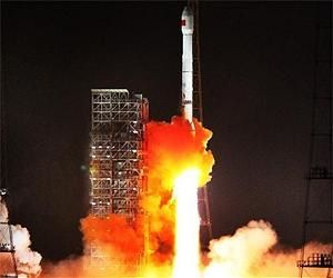
Intelligence reports from September and this month revealed China will test fire the new DN-2 missile from a ground base sometime in early to mid November.


The missile is described by intelligence agencies as a high-earth orbit interceptor designed to destroy satellites by ramming them at high speeds. The intelligence reports called the new missile a strategically significant counterspace weapon, said the officials familiar with the reports.


Testing a high-earth orbit anti-satellite missile would represent a major advance in China’s satellite-killing capability, which has been underway for more than a decade. High-earth orbit, also known as geosynchronous orbit, is the location of major communications and navigation satellites, which orbit at a distance of between 12,000 miles and 22,236 miles from earth.


China’s last ASAT test in 2007 destroyed a low-earth orbit weather satellite about 558 miles in space, causing an orbiting debris field of tens of thousands of pieces of metal that U.S. officials say will threaten orbiting satellites and human space travelers for 100 years.


U.S. officials said it is unlikely China will conduct an impact test of a kinetic kill vehicle against an aging weather satellite as occurred in 2007, although the possibility of a second, major debris-causing test cannot be ruled out.


Instead, officials said the test most likely will be a demonstration of a precision-guided direct ascent missile flying out tens of thousands of miles.


“If the United States loses the strategic high ground of high-earth orbit [from a Chinese  high-altitude ASAT missile], we are in real trouble,” said one U.S. official.


U.S. Global Positioning System satellites, used for both navigation and precision missile guidance, are located in medium-earth orbit, or about 12,000 miles, and thus would be vulnerable to the new DN-2.


Whether or not the test is successful, development of the new high-altitude DN-2 ASAT reveals that China’s military is planning for future high-orbit space warfare despite seeking international agreements banning weapons in space.


China’s January 2007 ASAT test drew protests from the United States and other spacefaring nations, who saw it as a major threat to satellites used for both military and civilian purposes. That test also produced tens of thousands of pieces of space debris which threaten satellites.


A second possibility is the DN-2 missile test will be fired against a target missile, as occurred in 2010 as part of a joint Chinese ASAT-missile defense test.


Pentagon spokesmen declined to comment on the DN-2 ASAT program.


Michael Pillsbury, a former Reagan administration defense policymaker, stated in a 2007 report to Congress that Chinese military writers advocated covert deployment of sophisticated anti-satellite weapons system like the kind now being developed by the People’s Liberation Army for use against the United States “in a surprise manner without warning.”


“Even a small scale anti-satellite attack in a crisis against 50 U.S. satellites—assuming a mix of targeted military reconnaissance, navigation satellites, and communication satellites—could have a catastrophic effect not only on U.S. military forces, but on the U.S. civilian economy,” said Pillsbury, currently with the Hudson Institute. Chinese military writings also have discussed attacks on GPS satellites that are located in high-earth orbit, he stated.


ASAT a top-secret program


China’s anti-satellite missile system is a key element of the communist state’s growing arsenal of asymmetric warfare weapons, and remains one of Beijing’s most closely guarded military secrets.


Defense officials have said that with as few as 24 ASAT missiles, China could severely weaken U.S. military operations by disrupting global communications and military logistics, as well as by limiting celestial navigation systems used by high-technology weapons. Such an attack also would severely degrade U.S. intelligence gathering efforts against global targets, a key strategic military advantage.


A U.S. official familiar with reports of the ASAT test said China’s delay in conducting the test until after the Nov. 6 election is a sign Beijing wants to help President Obama’s reelection campaign. “It implies they’d rather have him reelected,” said the official.


The Obama administration has adopted conciliatory policies toward China’s military buildup and its large-scale human rights abuses. Critics say the administration also failed to hold Beijing accountable for its unfair trade practices and currency manipulation.


The administration’s questionable policies were revealed by a 2009 State Department cable that quoted Secretary of State Hillary Clinton as saying, “How do you deal toughly with your banker?”—a reference to China’s potentially coercive leverage over the United States through its large holdings of U.S. debt securities.


Richard Fisher, a Chinese military affairs specialist, said little is known publicly of the DN-2 missile. However, the DN-2 may be China’s designation for an ASAT missile and kill vehicle combination mounted on launchers dubbed KT-2, or KT-2A. This ASAT weapon is based on DF-31 or DF-31A road-mobile intercontinental ballistic missiles, respectively.


“ASATs derived from the KT-2 and KT-2A space launch vehicles have the potential to reach high earth orbits used by many strategic U.S. surveillance, communication, and navigation satellites,” said Fisher, with the International Assessment and Strategy Center.


Fisher said in 2002, during a military show in China, the KT-2A was touted by Chinese officials as having a 2,000-kilogram payload that could reach high-earth orbits.


“Since its appearance a decade ago, the KT series of space launch vehicles presaged what we now know, that a key Chinese strategic goal has been to deny outer space as a sanctuary to support American military operations,” Fisher said.


A KT-1 microsatellite launcher was displayed at the Zhuhai air show in 2000, and “it was fairly obvious that this could become the basis for an ASAT, and it was used as the basis for the SC-19 ASAT demonstrated successfully in January 2007,” Fisher said.


Because China will not join a verifiable space control agreement, “Washington has little choice, if it is to continue to deter China militarily, but to build far greater redundancy, passive and active defenses for outer space,” he said.


China ASAT caused space debris


U.S. officials estimate that China’s 2007 ASAT test that destroyed an aging weather satellite in low-earth orbit now accounts for 45 percent of all space debris in low-earth orbit.


After a year of stonewalling by China on the test, an official U.S. demarche, or protest note, was sent to Beijing in January 2008. According to a copy of the note made public by Wikileaks, the protest warned the Chinese government, “Any purposeful interference with U.S. space systems will be interpreted by the United States as an infringement of its rights and considered an escalation in a crisis or conflict.”


“The United States reserves the right, consistent with the [United Nations] Charter and international law, to defend and protect its space systems with a wide range of options, from diplomatic to military,” stated the protest, made by then-U.S. Ambassador to China Clark Randt.


A joint State Department-Pentagon report to Congress on export controls made public in April states that China is “developing space-based methods to counter ballistic missile defenses of the United States and our allies, including anti-satellite (ASAT) weapons.”


“As China advances in operational space capabilities, it is actively focusing on how to destroy, disrupt, or deny U.S. access to our own space assets,” the report said.


China is developing and refining its ASAT weapons as part of a “multi-dimensional program to limit or prevent the use of space-based assets by potential adversaries during times of conflict,” the report said.


“In addition to the direct-ascent [missile] ASAT program, China is developing other technologies and concepts for kinetic and directed energy for ASAT missions,” including electronic jamming of satellite communications and lasers that disrupt satellites, the report said.


ASAT weapons “have significant implications for anti-access/area-denial efforts against the United States in Taiwan Strait contingencies,” the report said. Those weapons and capabilities are being developed by China as a means to force the U.S. military out of Asian waters and territory and make it more difficult for U.S. forces to get into the region during a conflict, such as a defense of Taiwan. Other anti-access area denial weapons include anti-ship ballistic missiles, cyber warfare capabilities, and submarines.


Defense Intelligence Agency director Lt. Gen. Ronald L. Burgess told Congress in February that “China successfully tested a direct ascent anti-satellite weapon (ASAT) missile and is developing jammers and directed-energy weapons for ASAT missions.”


Burgess said that as “a prerequisite for ASAT attacks, China’s ability to track and identify satellites is enhanced by technologies from China’s manned and lunar programs as well as technologies and methods developed to detect and track space debris.”


Another ASAT test by China will likely undermine the Obama administration’s controversial space arms control proposal, introduced in January. Many in the Pentagon oppose the International Code of Conduct for Outer Space Activities over concerns it would place limits on U.S. space capabilities.


U.S. lagging in counterspace


Despite China’s continuing development of space weapons, the administration has done no research or development into so-called counterspace weapons and other capabilities that could deter China from its ASAT and anti-satellite laser and jammer arms, according to military officials. The opposition is based on the administration’s preference for arms control negotiations and agreements as a major element of its U.S. national security policies, the officials said.


Frank Rose, deputy assistant secretary of state for arms control, said in a speech in April that the space code of conduct would include legally nonbinding “transparency and confidence-building measures.”


However, a Pentagon Joint Staff assessment of the space code of conduct concluded that U.S. adherence to the code’s provisions would hurt U.S. space operations in several areas.


The Pentagon’s National Security Space Strategy from 2011 makes little mention of counterspace weapons. It states that U.S. policy is “to dissuade and deter” others from developing space weapons, without providing specifics.


The Pentagon indirectly demonstrated an ASAT capability in 2008 when it used a modified ship-based SM-3 anti-missile interceptor to shoot down a falling, low-earth orbit spy satellite that was considered a danger because its fuel tank might have passed through the atmosphere and landed on earth.


Cables detail PRC’s first ASAT test


According to a classified Jan. 12, 2010, State Department cable made public by Wikileaks, China conducted its most recent ASAT test on Jan. 11 of that year.


According to the cable, an ASAT missile designated SC-19 was fired from China’s Korla Missile Test Complex and successfully intercepted a CSS-X-11 medium-range ballistic missile launched from the Shuangchengzi Space and Missile Center.


The two missiles were tracked by U.S. missile warning satellites to an intercept point at an altitude of about 155 miles in space.


Until then, the SC-19 had been used previously to boost China’s first successful direct-ascent anti-satellite intercept on Jan. 11, 2007, when a missile rammed into China’s FY-1C weather satellite.


“Previous SC-19 DA-ASAT flight-tests were conducted in 2005 and 2006,” the 2010 cable said. “This test is assessed to have furthered both Chinese ASAT and ballistic missile defense [BMD] technologies.”


The cable contained a U.S. protest note to China on the 2010 test seeking an explanation for Chinese officials about the purpose of the test and “what steps were taken to minimize the creation of orbital debris.”


The cable said that since the 2007 ASAT test, the United States had urged China not to conduct further space weapons tests.


An earlier cable revealed that U.S. intelligence agencies had advance word of the 2010 space weapons test, and noted that China was not expected to provide notification in advance of the test, which proved accurate.


Other State Department cables revealed conflicting statements from Chinese officials on whether China planned to conduct future ASAT tests. Chinese Foreign Ministry official He Yafei unequivocally stated to U.S. officials in June 2008 that China would not conduct future ASAT tests. In July, China Lt. Gen. Zhang Qinsheng said there were no plans for an ASAT test in the near future.

Partager cet article
Repost0
16 octobre 2012 2 16 /10 /octobre /2012 12:35

X-37B1


16.10.2012 Boris Pavlichtchev, Rédaction en ligne - La Voix de la Russie


Les militaires américains veulent développer des systèmes spatiaux réutilisables de nouvelle génération. Le développement de ces systèmes ne devrait pas s’arrêter, même avec les réductions budgétaires, affirme le ministère américain de la Défense. Cependant, les nouveaux projets dans ce domaine ne sont plus financés aux États-Unis. Les experts estiment que des systèmes similaires pourraient apparaître au sein de l’armée à la suite de forte demande dans la composante civile de l’aérospatiale.


Le prix du transport d’un kilogramme de fret sur l’orbite terrestre reste aujourd’hui très élevé et se monte à plusieurs dizaine de milliers de dollars. L’utilisation des navettes spatiales réutilisables devait réduire les coûts, mais le prix du lancement a sensiblement augmenté. Fixé au départ à 20 millions de dollars, il a grimpé jusqu’à 1,5 milliard de dollars. Les missions militaires qui étaient destinées à l’origine pour des navettes de 100 tonnes, comme l’enlèvement de l’orbite des satellites de l’ennemi, n’ont jamais été réalisées. C’est au début du 21e siècle qu’est apparu l’appareil spatial sans pilote Boeing X-37B, dernière élaboration de la NASA. Deux exemplaires de ce modèle ont réalisé chacun une mission secrète, liée à l’amélioration de certaines technologies spatiales, explique le chef de l’Institut de politique spatiale Ivan Moisseev.


« Malgré le secret qui l'entourait, ce système avait des raisons explicites d’exister. Actuellement, les conflits armés sont principalement locaux et peuvent se produire dans différentes parties de la planète. Cet avion spatial a un grand avantage technique : il peut changer rapidement d’orbite et arriver sur le meilleur point. Et il est également capable de mettre en orbite des satellites spéciaux pour la surveillance et les communications ».


En plus des essais, le dispositif pourrait déjà effectuer certaines missions considère l'académicien de l'Académie russe d'astronautique Alexandre Jelezniakov.


« Il est difficile de dire s’il est utilisé par des militaires. S’il s’agit d'exploration, il est fort probable que l’appareil a déjà pu filmer la surface terrestre ».


Le X-37B n’est pas un appareil grâce auquel le Pentagone pourrait développer des lancements à coût bas. Son développement, commencé il y a 13 ans, n’apporte rien de révolutionnaire au secteur, si ce n’est le début de la construction d'appareils spatiaux de cette catégorie. Les militaires n’ont pas de projets alternatifs, poursuit Alexandre Jelezniakov.


« Les systèmes civils de cette classe existent uniquement sur le papier. Outre le tourisme spatial, je ne vois pas d’autre possibilité d'utiliser des avions spatiaux réutilisables ».


Un autre moyen d’économiser les ressources dépensées pour l’aérospatiale consiste à créer des fusées qui retournent sur Terre. Pour ce projet l'US Air Force a lancé un appel d’offres, auquel ont participé plusieurs géants du secteur, dont Boeing et Lockheed Martin. Un projet a plu au commandement américain, mais les commandes n’ont toujours pas été passées. Les militaires américains n’ont rien de prévu dans ce segment. En même temps, Elon Musk, fondateur de SpaceX, travaille actuellement sur un projet similaire pour le secteur civil. Sa société développe un train d’atterrissage pour la fusée Falcon 9. Et le Pentagone pourrait s’intéresser à son projet.


« Si Musk arrive à effectuer une percée dans ce domaine, les militaires s’y intéresseront et pourront passer des commandes pour le développement de systèmes similaires destinés à des missions militaires », poursuit Alexandre Jelezniakov.


Le Pentagone ne risque pas de révolutionner l’aérospatiale dans les prochaines années avec de nouveaux avions spatiaux ou fusées « low cost », capables d’atterrir sur un aérodrome militaire. Il ne fait aucun doute que la demande d'appareils de ce type va continuer d'augmenter, surtout dans le secteur civil. C’est pourquoi il est fort probable que des compagnies privées pourront commencer à les élaborer, plutôt que Lockheed Martin ou d’autres partenaires du Pentagone, habitués à obtenir des récompenses généreuses pour leurs réalisations. Avec un budget réduit, le ministère américain de la Défense commence à s’intéresser aux projets d’Elon Musk, sans toutefois comprendre comment SpaceX a pu développer des navires réutilisables avec des budgets aussi serrés.


Les experts de La Voix de la Russie estiment que le sort des élaborations dans le domaine militaro-spatial dépend beaucoup des hommes politiques et de leur vision du secteur de l'exploration spatiale. Car l’aérospatiale aux Etats-Unis est en train de balancer entre sa composante civile et militaire.

Partager cet article
Repost0
15 octobre 2012 1 15 /10 /octobre /2012 18:52

Astrium Services


15.10.2012 Boursier.com


Astrium (Groupe EADS) accélère encore son plan de transformation AGILE destiné à améliorer sa compétitivité. Le numéro un européen des technologies spatiales permute 2 de 3 trois directeurs de divisions pour renforcer son efficacité technique et commerciale sur le marché des satellites et des services satellitaires. A compter du 15 octobre 2012, Evert Dudok devient le CEO d'Astrium Services, tandis qu'Eric Béranger devient le CEO d'Astrium Satellites. Cette décision doit permettre d'instaurer une coopération encore plus étroite entre ces deux activités. Evert Dudok reste représentant d'Astrium en Allemagne où il est également Vice-président du groupement des entreprises aérospatiales (BDLI). Il prend aussi en charge la coordination industrielle avec Cassidian.


"Etre capable de produire à la fois des satellites et des services est un atout exceptionnel sur le marché spatial mondial", a expliqué François Auque, Président d'Astrium. "Eric Béranger et Evert Dudok apporteront chacun un regard neuf et avisé sur l'organisation et les pratiques de leur nouvelle activité et permettront de renforcer les synergies entre ces deux secteurs pour développer des offres innovantes pour nos clients".

Partager cet article
Repost0
15 octobre 2012 1 15 /10 /octobre /2012 18:50

Astrium Services


October 15, 2012 defpro.com


Swapping the roles will enhance the level of coordination between Astrium’s Satellites and Services divisions, two areas that are becoming ever more complementary in the global market


Astrium, Europe’s leading space technology company, is further accelerating its AGILE transformation plan by swapping roles for two of its three divisional chiefs. The move will make Astrium more competitive and enhance its technical and commercial capability in the satellite and space services markets.


As a result, on 15 October 2012 Evert Dudok will take over as Astrium Services CEO, with Eric Béranger moving in the opposite direction to become Astrium Satellites CEO. The switch will bring about even closer cooperation between the two divisions.


“The ability to provide satellites and services at the same time is an exceptional asset in the global space market,” said Astrium CEO François Auque. “Eric Béranger and Evert Dudok will each be able to take a fresh and informed view of the organisations and activities at their new divisions and they will help strengthen synergies between the two areas to develop innovative products and services for our customers.”


Among other satellites, Astrium Satellites has manufactured the radar observation satellites TerraSAR-X and TanDEM-X, the very-high-resolution optical Pléiades constellation, the optical high resolution satellites Spot 6 and 7, and the secure military satcoms Skynet 5 constellation, which are operated by Astrium Services. The two Astrium divisions are also working together on the future European Data Relay System (EDRS) in conjunction with the European Space Agency (ESA) and their partners.


Born in 1959 in the Netherlands, Evert Dudok began his career with Deutsche Aerospace AG (DASA) in Germany, having completed summa cum laude a degree in electronic engineering at the Eindhoven University of Technology in 1984. After successfully working in the field of antennas, telecommunications and navigation, he was appointed head of Astrium Space Transportation in 2005, and then took over as CEO of Astrium Satellites in 2007. The division is now one of the world’s leading satellite manufacturers, not only in the fields of commercial and military telecommunications but also in Earth observation, science and navigation and is a world leader in satellite equipment.


Dudok will continue to represent Astrium in Germany, where he is also Vice-President of the German Aerospace Industries Association (BDLI). He will also be taking charge of industrial coordination with Cassidian.


Eric Béranger founded Astrium Services in 2003. Born in 1963, and a graduate of France’s École Polytechnique, he oversaw year-on-year growth of nearly 50 percent for Astrium’s youngest division prior to the acquisition of Vizada in 2011. A graduate of France’s Advanced School of Telecommunications (ENST), Béranger worked for France Telecom and Société Générale earlier in his career before joining Matra Marconi Space (now Astrium Satellites). He has also been Chairman of the European Satellite Operators’ Association (ESOA) since 2011.


Astrium Services is now one of the world’s largest satellite service providers and employs more than 3,000 people. It offers military, governmental and commercial telecommunications services, as well as Earth-observation satellite services.

Partager cet article
Repost0
15 octobre 2012 1 15 /10 /octobre /2012 11:35

Galileo.svg


13 octobre Aerobuzz.fr


Le 12 octobre 2012, à 20h15 (heure de Paris), le lanceur Soyouz a réussi son troisième lancement depuis le Centre Spatial de Guyane française, Port spatial de l’Europe. Le lanceur russe a mis en orbite deux nouveaux satellites de la constellation européenne de navigation par satellite Galileo, 12 mois exactement après les deux premiers, mis en orbite en octobre 2011 lors du premier vol de Soyouz depuis la Guyane française.


- Développé par la Commission Européenne en collaboration avec l’ESA, le programme Galileo est destiné à permettre à l’Europe de disposer de son propre système de navigation par satellite. Galileo doit s’appuyer sur un minimum de 14 satellites avant d’être opérationnel. A terme, il en disposera d’une trentaine.

Partager cet article
Repost0
9 octobre 2012 2 09 /10 /octobre /2012 07:40

SEF08-00071 GPS I II IIF th


Oct 09, 2012 (SPX)


Cape Canaveral AFS FL - The Global Positioning System (GPS), which military, commercial, and civilian users rely on for accurate navigation, is becoming more capable with deployment of the third Boeing GPS IIF for the U.S. Air Force. The IIF model is the most advanced GPS satellite to date.


SVN-65 is on orbit and performing as expected following liftoff at 8:10 a.m. Eastern time from Cape Canaveral Air Force Station aboard a United Launch Alliance Delta IV rocket. Controllers confirmed initial contact with the spacecraft at 11:43 a.m. Eastern time.


The satellite's GPS signals will be turned on and tested within a few days.


"With this third IIF satellite now on orbit, Boeing continues to deliver more precise navigation and timing capabilities for military and commercial uses worldwide," said Craig Cooning, vice president and general manager of Boeing Space and Intelligence Systems.


GPS IIF is delivering greater navigational accuracy through improvements in atomic clock technology; a more secure and jam-resistant military signal; a protected, more precise, and interference-free civilian L5 signal, and an extended design life.


Following a sequence of maneuvers and other on-orbit tests, SVN-65 will be placed into medium Earth orbit.


After the spacecraft's safety is validated, the Air Force will verify its operability with the rest of the on-orbit constellation and the Boeing-built ground control system known as the Operational Control Segment.

Partager cet article
Repost0
4 octobre 2012 4 04 /10 /octobre /2012 07:55

Galileo.svg


3 October 2012 aerospace-technology.com


The European Space Agency's (ESA) second pair of Galileo navigation satellites, Galileo Flight Model 3 (FM3) and Galileo Flight Model 4 (FM4), are ready for launch aboard a Soyuz ST-B vehicle from the European spaceport in French Guiana on 12 October.


Following launch, both the 'in-orbit validation' (IOV) satellites will join the first two Galileo satellites that were sent into space in 2011.


The latest launch will be a significant milestone for ESA's Galileo programme as four satellites are required to fix navigational errors in order to enable full system testing.


ESA said that two satellites' tanks have been filled up with hydrazine fuel to maintain their behaviour and orbital position during the 12-year stay in space.


The Fregat fourth stage of the Soyuz ST-B rocket will place the satellites into the orbit, preventing them from carrying extra fuel to position themselves into planned orbits.

"The latest launch will be a significant milestone for ESA's Galileo programme."


In addition, the twin satellites are temporarily equipped with aluminium plates on each side to protect their solar panels and are attached to a dispenser that will hold them safely during launch until pyrotechnic mechanisms release them sideways in opposite directions at an altitude of 14,429 miles above the Earth.


The satellites, dispenser and Fregat upper stage will undergo testing ahead of the fitting of protective launch fairing on 4 October.


In order to achieve full operational capability (FOC), the validation phase will be followed by deployment of further satellites and ground segment components.


The first four Galileo satellites were developed by a consortium led by Germany-based EADS Astrium, with the company producing the platforms and Astrium UK responsible for payloads. They were assembled and verified in Rome by Thales Alenia Space.


Galileo is a programme initiative of the European Commission and the European Space Agency (ESA), and each Galileo spacecraft features an atomic clock for navigation and a powerful transmitter to allow precise broadcast of navigation data globally.

Partager cet article
Repost0
3 octobre 2012 3 03 /10 /octobre /2012 17:35

SEF08-00071_GPS_I_II_IIF_th.jpg


CAPE CANAVERAL AIR FORCE STATION, Fla., Oct. 3, 2012 Boeing


SVN-65 to further enhance constellation's power, precision and capacity


 The third of 12 Global Positioning System (GPS) IIF satellites Boeing is building for the U.S. Air Force is ready to make the GPS system even more accurate, reliable and secure after successfully completing final checkout for launch.


SVN-65 is scheduled to lift off from Cape Canaveral Air Force Station on Oct. 4 at 8:10 a.m. Eastern time aboard a United Launch Alliance Delta IV vehicle.


"As the GPS IIFs become operational, they are ensuring that the Air Force can meet the current and future needs of both military and civilian users," said Col. Bernie Gruber, director of the U.S. Air Force Space and Missile Systems Center's Global Positioning Systems Directorate.


GPS is a global utility providing highly accurate position, navigation and timing services to billions of people around the world. The GPS IIF satellites are sustaining and modernizing the network with a number of enhancements, including improved atomic clock technology, a more jam-resistant military signal and a protected and more powerful civilian signal. The satellites also feature a 12-year design life for long-term service and reduced operating costs.


"Boeing has worked alongside the Air Force for many years to continuously sustain and improve the GPS constellation," said Craig Cooning, vice president and general manager of Boeing Space & Intelligence Systems. "This new fleet of 12 GPS IIFs will form the core of the GPS constellation for the next decade."


SVN-65 was shipped to the Cape from El Segundo, Calif., on July 9 aboard a Boeing-built C-17 Globemaster III military transport. The satellite has undergone a series of prelaunch tests that validated its operational readiness, including its ability to communicate with the launch site and the Boeing-built Operational Control Segment.


Of the remaining nine GPS IIFs, three are completed and ready to be scheduled for launch as needed while six are in production. The Boeing Satellite Development Center in El Segundo uses an efficient "pulse line" manufacturing process adapted from Boeing commercial airplane assembly techniques.

Partager cet article
Repost0

Présentation

  • : RP Defense
  • : Web review defence industry - Revue du web industrie de défense - company information - news in France, Europe and elsewhere ...
  • Contact

Recherche

Articles Récents

Categories