Overblog
Suivre ce blog Administration + Créer mon blog
5 juillet 2011 2 05 /07 /juillet /2011 18:01

http://www.defense.gouv.fr/var/dicod/storage/images/base-de-medias/images/dga/1_programmes/vue-d-artiste-de-musis-credit-astrium/316117-1-fre-FR/vue-d-artiste-de-musis-credit-astrium.jpg

credit Astrium


July 5, 2011 defpro.com


Bonn | In the frame of the space programme MUSIS, OCCAR-EA awarded a 9-month contract to the three co-contractors Thales Alenia Space Italia, EADS Astrium France, and Thales Alenia Space France.


MUSIS (MUltinational Space-based Imaging System) is a collaborative programme for surveillance, reconnaissance and observation comprising several European military or dual-use satellite constellations of the next generation and complementing one another. Among these constellations, the space system CSG (Cosmo SkyMed Seconda Generazione) is under development in Italy and will generate radar images; CSO (Composante Spatiale Optique), the MUSIS space component realised under the leadership of France, will acquire optical pictures.


Sponsored by France and Italy, the MUSIS Federating Activities (FA) aim to interconnect the space systems mentioned above and guarantee mutual access by national users. The MUSIS FA Phase B–1 study is concerned with the preliminary definition of a “Common Interoperability Layer” bridging the gap between the national ground segments.


The possible participation of other MUSIS Nations in subsequent phases of these federating activities may be coordinated through the European Defence Agency, in the frame of the “EDA MUSIS Cat B Programme.”

Partager cet article
Repost0
1 juillet 2011 5 01 /07 /juillet /2011 11:30

http://www.shephard.co.uk/files/news/190x190/geoeye2.jpg


July 01, 2011 SHEPARD GROUP Source: Lockheed Martin


The Lockheed Martin team developing GeoEye's next-generation, high-resolution Earth-imaging satellite, known as GeoEye-2, has successfully completed the Space System Critical Design Review (CDR) two weeks ahead of schedule. The review validated the detailed design of the spacecraft and command and control portion of the ground system to ensure it meets all programme requirements for GeoEye's commercial and government users and marks the programme's transition to production.


Once operational in 2013, GeoEye-2 will be the world's highest resolution commercial satellite, providing highly accurate images to intelligence analysts, war fighters, and decisions makers across the globe.


The two-day space system CDR, conducted by Lockheed Martin and GeoEye at Lockheed Martin's Sunnyvale, Calif. facility, was completed seven months after the programme's Preliminary Design Review in November 2010. The CDR phase included a series of detailed examinations of the satellite's technical design as well as the command and control element of the ground system. The incremental reviews leading up to the final CDR verified that each aspect of the system would meet mission requirements.


Bill Schuster, GeoEye's chief operating officer, said, "We are very pleased with our GeoEye-2 programme's progress and timely completion of this milestone. GeoEye-2 will fulfill the increasing demands on our constellation and provide additional capacity for the US government and our global partners. When operational, the satellite will deliver the highest resolution and most accurate color imagery to our government and commercial customers."


"The successful outcome of this review, completed ahead of the planned schedule, is a testament to the team's strong commercial and government satellite system expertise and focus on operational excellence," said Allen Anderson, GeoEye-2 programme director for Lockheed Martin Space Systems Company. "Working alongside GeoEye, this team developed a robust design for GeoEye-2 that will meet the increasing demands for timely geospatial information, and we look forward to achieving mission success for our customer."


Lockheed Martin Commercial Launch Services will launch GeoEye-2 aboard an Atlas V rocket. GeoEye-2 will feature significant improvements to its predecessors, including enhanced tasking and the ability to collect more imagery at a faster rate with a new ITT camera.

Partager cet article
Repost0
30 juin 2011 4 30 /06 /juin /2011 11:50

USAF logo


EL SEGUNDO, Calif., June 30, 2011 /PRNewswire-USNewswire


LOS ANGELES AIR FORCE BASE -- The U.S. Air Force successfully launched the first Operationally Responsive Space prototype satellite aboard a Minotaur I launch vehicle at 11:09 p.m. EDT yesterday from Pad 0B at the NASA Wallops Flight Facility, Wallops Island, Va. ORS-1 deployed 12 minutes after launch.


This marks a great achievement by the Space and Missile Systems Center's Space Development and Test Directorate, the Operationally Responsive Space Office and their contractor teams.  ORS-1 is the Operationally Responsive Space Office's first operational prototype satellite and represents the potential of low-cost, tactically focused satellites designed to provide critical battlespace awareness capabilities to the joint warfighter.


"Words cannot express how proud I am of the entire ORS-1 team," said Col. Carol Welsch, SMC/SD Acting Director and ORS-1 Mission Director. "The men and women of the Space Development and Test Directorate, the Operationally Responsive Space Office, and our industry partners of Goodrich, ATK, and Orbital have all worked tirelessly to move forward on the concept of a responsive space capability designed to support the warfighter.  Their teamwork and dedication is simply inspiring."


Rapidly developing and fielding ORS-1 is an important step to demonstrating the possibilities to meet emerging and persistent warfighter needs in operationally relevant timelines.  "Our team was able to develop, integrate, test and launch this system in just over 30 months which is a remarkable achievement," said Colonel Welsch.


ORS-1 was initiated as a result of a requirement from the Commander, U.S. Strategic Command to the ORS Office to support U.S. Central Command.

Partager cet article
Repost0
28 juin 2011 2 28 /06 /juin /2011 07:10

http://fr.rian.ru/images/18795/81/187958191.jpg


MOSCOU, 27 juin - RIA Novosti


Les troupes aérospatiales russes ont tiré lundi depuis le cosmodrome de Plessetsk un lanceur Soyouz-U avec un satellite de la série Kosmos à bord, a annoncé à RIA Novosti le porte-parole des Troupes aérospatiales, Alexeï Zolotoukhine.

"Un lanceur de classe moyenne Soyouz-U avec un satellite de la série Kosmos a été tiré lundi à 16h00 GMT depuis le pas de tir n°16 du cosmodrome de Plessetsk pour le compte du ministère russe de la Défense", a-t-il déclaré.

Le premier tir d'une fusée-porteuse Soyouz-U depuis Plessetsk a eu lieu le 18 mai 1973. Depuis, 433 lanceurs ont été tirés qui ont mis en orbite près de 430 satellites.

Conçu par le Bureau d'études Progress de Samara, le lanceur Soyouz-U est destiné à placer sur orbite des vaisseaux habités et des cargos spatiaux, ainsi que des satellites de télécommunications, de télédétection et météorologiques. Il peut emporter une charge utile de 6.950 kg.

Partager cet article
Repost0
23 juin 2011 4 23 /06 /juin /2011 07:55

http://www.astrium.eads.net/media/image/import/738_photo1.jpg


MADRID, June 22 (UPI)


Spain is on track to become the first European country to have a dual Earth observation system, radar and optical, for both civilian and military use.


Defense Minister Carme Chacon said radar technology installed on the satellite, which is totally of Spanish design and manufacture, will enable up to 100 images of the Earth's surface to be taken per day at a resolution of up to 1 yard.


In three years' time, this capacity will be joined by that of the Ingenio satellite and its optical technology.


"With the Paz and Ingenio satellites, our military will have their own observation systems, thus multiplying our autonomy in terms of obtaining information and better protecting the interests of Spain," she said.


Chacon made her remarks at a formal presentation of the Paz satellite this month.


The presentation ceremony took place at a facility of EADS CASA Espacio, and was attended by the Chief of Defense Staff Jose Julio Rodriguez; State Secretary for Defense Constantino Mendez; and the Secretary-General for Industry Teresa Santero.


Officials from Hisdesat and Astrium Espana were also in attendance.


The Paz satellite was ordered from Hisdesat by the Ministry of Defense at the end of 2007 under the National Earth Observation Plan to meet the operational requirements of the Spanish armed forces.


Hisdesat contracted the design and manufacture of the satellite to EADS CASA Espacio, meaning this is the first time that the Spanish space industry has undertaken the challenge to build a satellite of this size and complexity to be assembled and manufactured entirely in Spain.


Chacon stressed that the Paz satellite, which will be in orbit in 2013, will be able to detect the position of any ship in the world that could possibly become the victim of hijacking through an automatic AIS identification system. It also will enable the tasks of border control monitoring, the verification of international treaties, the monitoring and assessment of natural disasters and environmental control to be carried out more easily and effectively.


"The Paz satellite will multiply the operational capabilities of our armed forces both within and beyond our borders," she said.


Spain's aerospace industry was credited for the innovation that made such progress possible.


"Thanks to the support from the Ministry of Defense and the Ministry of Industry, Tourism and Trade, we have traveled the long and arduous path to creating a satellite fitted with sophisticated technology that will enable our country to play a very important role in the field of high-resolution satellite imaging," Managing Director of Hisdesat Roberto Lopez said.


Hisdesat said the satellite will be launched from Russia near the end of next year.


The Paz satellite, which has been designed for a 5 1/2-year mission, measures about 6.5 feet in height and about 3.8 feet in diameter. It has a total weight of nearly 3,100 pounds.


Spain's National Institute for Aerospace Technology is responsible for developing the terrestrial aspects of the program, which include control and monitoring stations in Torrejon, near Madrid, and Maspalomas in the Canary Islands, as well as data processing and storage centers.

Partager cet article
Repost0
23 juin 2011 4 23 /06 /juin /2011 07:00

http://www.asdnews.com/data_news/ID36330_600.jpg


Jun 22, 2011 ASDNews Source : NASA


Southern California's high desert has been a stand-in for Mars for NASA technology testing many times over the years. So it was again as NASA's Dryden Flight Research Center and Jet Propulsion Laboratory flight-tested the next Mars rover's landing radar, using an F/A-18 aircraft.


The Mars Science Laboratory, or MSL mission, is following up the grand success of the twin Mars Exploration Rovers, Spirit and Opportunity, which tirelessly explored Mars for the last seven years. The MSL mission is part of NASA's Mars Exploration Program, a long-term robotic exploration effort of the red planet. The mission is managed by JPL in Pasadena, Calif.


NASA Dryden's F/A-18 carried a Quick Test Experimental Pod, or QTEP, that housed the MSL test radar, attached underneath the aircraft's left wing. The flight profile was designed to have the F/A-18 climb to 40,000 feet, then make a series of subsonic, stair-step dives over Rogers Dry Lake at angles of 40 to 90 degrees in order to simulate what the MSL's radar will see during entry into the Martian atmosphere. The F/A-18 pulled out of each dive at 5,000 feet.


"Not only has the working relationship between Dryden and JPL been exemplary, but we're proving the viability of suborbital flight testing of critical space hardware," says Mike Holtz, Dryden's MSL project lead and F/A-18 backseat flight test engineer. "This has been a unique opportunity to test equipment in a representative environment prior to the space flight hardware blasting off to Mars," Holtz says.


Data collected by these flights will be used to finesse the MSL's landing radar software to help ensure that it calibrated as accurately as possible.


The current MSL landing radar flight tests with the F/A-18, which concluded June 20, focused on the on-chute acquisition portion of the MSL's entry into the Martian atmosphere, when the spacecraft is suspended from its parachute. Last June, NASA Dryden supported MSL radar testing aboard a helicopter at Dryden, which focused on the powered descent portion of the MSL flight profile.


Overall, the flight envelope for MSL radar operations is much larger than it was for the Mars Exploration Rovers and Phoenix Lander, due to the MSL radar operating at higher altitudes than either of its predecessors. Those previous Mars missions tested the landing radar with only a helicopter, but testing with both the helicopter and the F/A-18 is required this time around.


The test results will be analyzed to verify the radar performs as expected throughout its flight envelope. If any unexpected performance is uncovered, the JPL team has the ability to modify the parameters and/or software any time leading up to the rover's scheduled landing in August 2012.


"It was very gratifying to finally see wheels-up on the F/A-18 with the MSL-configured pod after almost five years of development," says Steven Lee, JPL's MSL guidance, navigation and control lead. "Our flights have gone well and we've already collected some very valuable data. We look forward to continuing this exciting joint Dryden/JPL effort."


NASA Dryden's part in the MSL program has included instrumentation integration, project planning, flight article environmental testing, airspace coordination, logistical support for the QTEP and helicopter operations that were conducted last year, and flight test expertise during JPL-conducted technical reviews.


Dryden support during the current flight phase of the project included precision flying of the center's F/A-18 aircraft. The MSL radar was controlled during flight by Holtz aboard the aircraft. Dryden's mission control rooms have been fully utilized as well, providing monitoring of on-board instrumentation and downlink of in-flight MSL radar operation telemetry and video from chase aircraft and ground-based long-range cameras.


"This cooperative relationship between JPL and Dryden serves as a fine example of inter-center relationships," Holtz said. "Mutual respect and dedication to the project has fostered a productive work environment and has allowed us to work through some challenging problems and set-backs."


The MSL rover, named Curiosity, is scheduled for shipment from JPL to NASA's Kennedy Space Center in Florida in late June where it will be readied for a launch window between Nov. 25 and Dec. 18, 2011. The rover should arrive at Mars in August 2012. After Curiosity lands on Mars, researchers will use the rover's 10 science instruments during the following two years to investigate whether the landing area has ever offered environmental conditions favorable for microbial life.

Partager cet article
Repost0
23 juin 2011 4 23 /06 /juin /2011 05:40

http://cdnpullz.defencetalk.com/wp-content/themes/dtstyle/scripts/timthumb.php?src=/wp-content/uploads/2009/05/spacebasedlaserreboost.jpg&w=375&h=245&zc=1


Jun 22, 2011 By Amy Svitak AviationWeek.com


LE BOURGET - Astrium Space Transportation is pitching a €1 billion ($1.4 billion) missile defense system to the French defense ministry — an unsolicited proposal that would hinge on a successful flight test of the midcourse interceptor the company says could be conducted by 2016.


CEO Alain Charmeau says the flight demo, which would launch and destroy a target at the edge of space during the midcourse segment of the target’s ballistic launch trajectory, would cost €200-300 million.


Speaking to reporters here June 21, Charmeau said Astrium’s proposed missile defense system could be funded as an in-kind contribution to NATO, which last year announced plans to expand its missile defense shield to include Europe.


“France has a chance either to contribute to NATO by buying some U.S. systems, which are the only ones available today, or we have the opportunity to use our existing space technologies in order to contribute in-kind contributions,” says Charmeau, adding that Astrium’s proposal would be delivered to the French armaments agency, DGA, in the coming days.


If successful, the intercept test could lay the groundwork for a broader shield in Europe.


Charmeau says missile defense is one of the top three development priorities for the French defense ministry in the coming years. He is optimistic that missile defense funding will be available despite declining military budgets in France and other NATO-member countries.


“It’s a matter of priorities,” he says. “I believe there is room for missile defense in the next years.”


Charmeau says Astrium’s experience building Earth-observation satellites and missile systems for France makes it well-suited to supply an anti-missile system for NATO. The company’s proposal is modeled after its Spirale early-warning satellite demonstration launched for the French defense ministry in 2009.  


In addition, Astrium space transportation has spent the past 10 years working with U.S. engineering firm SAIC to develop architecture studies for NATO missile defense systems.


“We believe with something around €1 billion you can develop an interceptor program,” Charmeau declares. “We know very well how to send an object [into] space.”

Partager cet article
Repost0
20 juin 2011 1 20 /06 /juin /2011 18:10

http://www.defense.gouv.fr/var/dicod/storage/images/base-de-medias/images/dga/1_programmes/helios-2/226712-1-fre-FR/helios-2.jpg 


20/06/2011 Ministère de la Défense


La direction générale de l’armement (DGA) a livré le 14 juin 2011 aux forces françaises, la première version de Pharos (portail hôte d’accès au renseignement de l’observation spatiale), un portail d’accès à des systèmes d’imagerie satellitaire militaires et civils. Le contrat Pharos a été notifié par la DGA en septembre 2007 à Cassidian (mandataire) et Astrium (co-traitant) pour un montant de 20 millions d’euros.

Hélios 2


Pharos est un portail qui donne un accès direct aux images satellites optiques et radars depuis la métropole et les théâtres d’opération. Concrètement, il permet à ses utilisateurs de programmer à distance les différents systèmes satellitaires auxquels la défense française a accès, de visualiser en ligne le catalogue des images archivées et partagées par la communauté du renseignement français, de mutualiser les demandes d’images aux centres de programmation, et d’acheminer les images sur les théâtres d’opération.


Les systèmes accessibles via Pharos sont Hélios et les satellites civils (via le point de contact défense) puis dans une seconde version livrée au second semestre 2011, les satellites italiens Cosmo-Skymed et allemands SAR-Lupe et enfin les satellites Pléiades lorsqu’ils seront en orbite.


La DGA a livré 24 « cellules » Pharos : 8 sont fixes et installées dans des emprises militaires (base aérienne, base navale…) tandis que 16 cellules projetables peuvent être déployées sur des théâtres d’opération, des navires de la marine ou au sein d’états-majors projetés. 10 autres cellules fixes seront livrées à l’automne. Une cellule projetable Pharos est actuellement déployée sur le porte-avions Charles-de-Gaulle  dans le cadre des opérations aériennes en Libye.


Pharos est en démonstration au salon du Bourget sur le stand du ministère de la Défense (ST U20).

Partager cet article
Repost0
20 juin 2011 1 20 /06 /juin /2011 11:55
Pharos, portail d’accès à l’ensemble des ressources spatiales


20/06/2011 Domitille Bertrand


Dans le domaine du renseignement d’origine spatiale, la France fait un nouveau pas, en se dotant du portail hôte d’accès au renseignement de l’observation spatiale (Pharos). Il permet de fédérer l’accès aux images de satellites européens d’observation de la Terre utilisés dans le cadre d‘opérations militaires et de renseignement.


« Jusqu’à maintenant, lorsque les forces françaises avaient besoin d’une vue satellite, pour de la veille stratégique ou un besoin tactique, elles en faisaient la demande au centre militaire d’observation par satellites (CMOS), à Creil. Une fois la requête traitée par le CMOS, les images étaient gravées sur DVD puis expédiées au demandeur. Et, pour chaque demande, il fallait analyser sur les segments sol (systèmes qui regroupent tous les moyens nécessaires à l’envoi, à la réception et aux traitements des données échangées entre les satellites et la Terre) des différents satellites, quel serait le meilleur à utiliser, en fonction de leurs heures de passage au-dessus de la zone à observer, des conditions météo et bien sûr du type d’image - radar, infrarouge… - demandé », explique Harold Hoff, architecte-concepteur d’ensemble du programme SSO (segment sol d’observation) à la direction générale de l’armement (DGA).


A partir de juin 2011, les requêtes et les recherches des usagers seront toutes rassemblées sur un système unique : Pharos, le portail hôte d’accès au renseignement de l’observation spatiale. « Parmi les avantages notoires, il faut bien évidemment souligner un gain de temps immense, puisque les images pourront être commandées directement depuis un théâtre d’opération extérieure où elles seront diffusées par voie électronique une fois produites » souligne Harold Hoff. Les données pourront également être archivées et partagées en ligne par toute la communauté Pharos (cette communauté regroupe les différentes armées et les services de renseignement français) reliée au système, ce qui permettra de disposer immédiatement d’images déjà produites ou d’éviter des commandes multiples sur une même zone.


« Simplifier le recours aux images satellites, en fédérant les données »


La France a accès à plusieurs systèmes d’imagerie satellite, systèmes complémentaires aux caractéristiques différentes :

- dans le domaine optique, on retrouve les satellites à très haute résolution Hélios qui seront complétés dès 2012 par le premier des deux satellites Pléiades, système à vocation civile et militaire ;

- dans le domaine de l’imagerie radar, des partenariats ont été mis en place avec l’Italie et avec l’Allemagne pour avoir accès à leurs systèmes nationaux, respectivement Cosmo-SkyMed et SAR-Lupe.


Ces deux systèmes satellitaires ont une même vocation : outils essentiels aux forces, ils permettent d’accéder à des renseignements stratégiques, en obtenant par exemple des éléments sur des positions, des capacités ou des matériels ennemis. Cependant, ils sont très différents : les satellites optiques sont comparables à des appareils photo numériques ultra-performants. Ils ont pour avantage de donner des images exploitables immédiatement, avec pour seule contrainte que l’observation soit réalisée de jour et en l’absence de couverture nuageuse (éventuellement de nuit pour les images infrarouges). À l’inverse, les satellites radar effectuent des prises de vues de jour comme de nuit, quelle que soit la météo sur la zone observée. De plus, ils sont plus difficiles à leurrer. Par contre, l’exploitation des images radar nécessite l’intervention d’un interprète d’images bien entrainé et disposant d’outils (poste d’exploitation) adaptés.


Un système franco-français


Si le cœur du Pharos est implanté lui aussi au CMOS à Creil, 18 cellules distantes sont réparties sur tout le territoire national et 16 cellules sont prêtes à être projetées sur des théâtres d’opérations extérieures. Ces cellules, constituées d’un serveur et d’un poste de travail, sont reliées entre elles grâce à une connexion sécurisée et chiffrée. Plus de 600 Go de données, issues de la production des segments sol, seront intégrées chaque jour dans Pharos. « Dès la fin de la phase finale de vérification prévue courant juin 2011 le porte-avions Charles-de-Gaulle pourra accéder à cette capacité au moyen de la station projetable qu’il a embarquée » ajoute Harold Hoff.


Le portail Pharos sera présenté au salon du Bourget 2011 comme un atout majeur dans le domaine du renseignement d’origine spatiale. Néanmoins, ce dernier né d’un travail commun entre l’état-major des armées (EMA), la DGA et les industriels Cassidian et Astrium (tous deux du groupe EADS) restera bien un système franco-français : « Nous touchons ici au domaine du renseignement ; les images, photos, documents commandés et archivés seront pour la plupart classés secret-défense.  Il en va de la sécurité des forces ! »

Partager cet article
Repost0
18 juin 2011 6 18 /06 /juin /2011 05:45

http://www.satnews.com/images_upload/1734931125/Goodrich_ORS-1.jpg

source satnews.com


June 17, 2011 defpro.com


PARIS | Goodrich Corporation the prime contractor for the ORS-1 (Operationally Responsive Space) satellite has successfully completed all of the major program milestones and the ORS-1 satellite has been delivered to NASA's Wallops Island Flight Facility at the Mid-Atlantic Regional Spaceport (MARS) in Virginia, for launch aboard a Minotaur 1.


The ORS-1 satellite is the first satellite developed to support Combatant Command operations and will provide battlespace awareness supporting U.S. Central Command's mission needs. Following the delivery of the bus from its sub-contractor ATK Space Systems, Goodrich has successfully completed several major milestones:


In October 2010 the payload and spacecraft bus were successfully integrated, paving the way for environmental and acceptance testing.


Rigorous environmental testing began in December 2010 enabling the Goodrich team to ensure that the satellite will function and perform in extreme conditions. The tests included duplicating extreme hot and cold temperatures the satellite will experience during launch and when in space.


Pre-ship review and preparation for shipment was successfully completed in April 2011.


Goodrich is the lead systems integrator for the ORS-1 satellite and is also providing the satellite's sensor payload. The payload leverages the Goodrich SYERS-2 multi-spectral sensor, the primary imaging sensor on the U-2 reconnaissance plane. The bus, built for Goodrich by ATK Space Systems is based on the bus built for TacSat-3. A Goodrich ground segment formats the data from the payload sensor to be compatible with the processing, exploitation and dissemination infrastructure used for the operational SYERS-2 sensor.


A model of the ORS-1 satellite is on display at the Goodrich pavilion.

Partager cet article
Repost0
17 juin 2011 5 17 /06 /juin /2011 11:15

European Defence Agency


16 Jun 2011 By JULIAN HALE DefenseNews


BRUSSELS - The European Defence Agency (EDA) is set to sign an administrative agreement with the European Space Agency (ESA) at the Paris Air Show on June 20 to improve cooperation between the two agencies.


In broad terms, the EDA aggregates security and defense requirements for its 26 member states, while the ESA does the same for civilian requirements for its member states.


The arrangement will include identifying capability gaps that could be filled by space assets in carrying out EU policies (such as Common and Security Defence Capability missions on the military side) and looking at opportunities for pooling and sharing.


"Satellite communications might be an area for pooling and sharing," an EDA official said. "All member states will have to replace them by about 2020. For the conduct of operations, space-based assets are simply essential."


One area that the two agencies will explore is an EU space situational awareness capability.


"This has nothing to do with space weaponization but is about ensuring the safety of European space assets (such as critical infrastructure) from natural or potentially man-made (e.g., space debris) threats," the EDA official said.


For example, space weather (e.g., solar flares) can disturb the functioning of satellites, be they military or civil, said the official.


The official contrasted the idea of developing an EU space situational awareness capability with the development of Galileo, which is a civil system under civil control that may have military users.


"This is the first time (with the EU space situational awareness capability) that the EU has said from the outset that this is a dual-use capability," the official said. "This means that it will serve and be based on the requirements of the civil and military community."


That process, which will also involve the European Commission and the EU's External Action Service, is expected to hit an important milestone in the summer when the EU's political and security committee validates an aggregated set of civil and military requirements in this area.


Another area for potential cooperation is unmanned aerial systems (UASs).


Here, both the EDA and ESA have done feasibility studies on UAS command and control via satellite, and a demonstration mission is expected to be carried out around 2011-12.


The EDA-ESA administrative arrangement foresees the possibility of the two agencies exchanging personnel for specific projects for a limited period of time and for each agency to be invited to the other's high-level meetings, but there will be no shared office or merging of the two bodies.


Other activities of common interest focus on intelligence, surveillance and reconnaissance, and civil-military synergies in Earth observation and critical space technologies where the EU does not want to be totally dependent on suppliers from outside the EU, an EDA document says.


The background to this effort is a space policy resolution by EU member states in November 2010, in which they invited the commission, the EU Council assisted by EDA, together with member states and ESA "to explore ways to support current and future capability needs for crisis management through cost-effective access to robust, secure and reactive space assets and services (integrating global satellite communications, Earth observation, positioning and timing), taking full advantage of dual-use synergies as appropriate."


Separately, the EDA official said negotiations with Switzerland for an administrative arrangement were ongoing, although there was no date yet for the signing of an agreement.

Partager cet article
Repost0
15 juin 2011 3 15 /06 /juin /2011 17:00


June 15, 2011: STRATEGY PAGE


Six years ago, the U.S. Department of Defense began developing very small satellites. Thes smallest ones so far are called CubeSats. That is, their volume is no more than one liter (10x10cm or 4.1x4.1 inches) and weigh no more than 1.3 kg (three pounds). The military got the idea from the increasing use of commercial nanosatellites (which weigh no more than 6.8 kg/15 pounds). The U.S. military launched its first CubeSats last December (piggybacking with a larger bird). CubeSats can be used for photo or electronic surveillance, or communications. The rapid advances in communications and sensor technology during the last decade have made it possible to build a useful reconnaissance satellite weighing less and less. A tiny satellite like this would include solar panels, to provide power. British firm Surrey Satellite Technology LTD pioneered this technology a decade ago, and made it possible to get scientific satellites in orbit for a fraction of the usual price.


These tiny satellites also have the advantage of being much more difficult to be tracked from the ground. If there are successful satellite attacks, then the nanosatellites can be sent up to replace the lost birds. The lightweight satellites (Surrey has a line of standard small satellites, from CubeSats to 200 kg minisats) can be put in orbit using smaller, solid fuel, boosters. The U.S. Navy proposed using the ICBMs fired from SSBNs (ballistic missile carrying nuclear subs), which can be put to work much more quickly than the usual liquid fueled launcher. But the solid fuel ICBMs can only put a ton or so (usually less) into orbit. With CubeSats and nanosatellites, this is not a problem. With Surreys standard nanaosatellites, sold ready for the installation of your own payload, it's pretty clear what the military minisats would look like, and how they would get into orbit.


For the last decade, the U.S. Air Force has been developing and launching lightweight (under half a ton) TacSat reconnaissance satellites. The first one was launched seven years ago, while TacSat3 went up two years ago, and was provided data to combat commanders in Afghanistan until earlier this year. Troops on the ground could communicate with the TacSat, which provided photo-reconnaissance.


TacSat is not alone up there. There are a number of lightweight photo satellites in use. Two years before the 109 kg/240 pound TacSat 1 went up, Israel launched the 300 kg/660 pound Ofek-5. While TacSat 1 had only an infrared camera, regular camera, (both low rez) and a radio signals collection package, Ofek 5 a had one meter resolution digital camera, good enough to tell the difference between a tank and a car and spot a group of tanks assembling for attack.


The 400 kg/882 pound TacSat 3 had a wider array of sensors, including a hyperspectral (can detect a large range of light sources) imager, an Ocean Data Telemetry Microsatellite Link and the Space Avionics experiment. TacSat 3 sensors have a four meter resolution, but the ARTEMIS hyperspectral sensor can detect vehicles hidden in forests, as well as buried roadside bombs.


The problem with these microsatellites is cost. The cheapest way to launch these small birds is via a solid fuel ICBM (preferably one that is being retired). Even there, the launch cost is going to be about $20 million per satellite. That's why even smaller satellite became popular, because they were compact enough to be piggybacked with a larger satellite.

Partager cet article
Repost0
14 juin 2011 2 14 /06 /juin /2011 12:25

http://upload.wikimedia.org/wikipedia/commons/b/b7/SBIRS-Architecture.png


14 juin 2011 par Optro & Défense


A l’instar des travaux menés par la France dans le cadre du PEA SPIRALE mais dans une autre ampleur, le système d’alerte infrarouge spatiale développé par Lockheed Martin a réussi sa mise en orbite, suite à son lancement de Cap Canaveral (Floride) le 7 mai.

La mise en orbite

L’équipe au sol (US Air Force / Lockheed Martin) aura du piloter 6 mises à feu du moteur d’apogée pour placer ce système d’alerte infrarouge spatial (Space Based Infrared System – SBIRS)  en orbite géostationnaire, comme le montre l’illustration ci-dessous. L’équipe a ensuite commandé le déploiement des panneaux solaires et des antennes du satellite pour activer ses capteurs infrarouges sophistiqués et débuter des essais en orbite.


Le satellite SBIRS est l’un des satellites infrarouges militaires les plus avancés technologiquement. Mis au point pour améliorer l’alerte rapide des lancements de missiles dans le monde entier, il constitue un soutien au système de défense antimissile des États-Unis.

Une succession ambitieuse

Les Etats-Unis disposent depuis plus de 40 ans de cette capacité de détection, notamment avec leurs satellites géostationnaires DSP puis DSP-I (Defense Support Program – Improved). SBIRS a pour objectif de les remplacer non seulement pour accroître la capacité de surveillance des tirs de missile mais aussi obtenir des renseignements opérationnels pour des missions de combat classiques. Le système doit ainsi apporter une réponse à différentes problématiques : alerte missile fiable,  renseignement technique (caractérisation de signatures infrarouges) et appui aux théâtres d’opérations.


Le système met en oeuvre des capteurs matriciels et à balayage très sophistiqués qui offrent une sensibilité améliorée dans l’infrarouge. La nouvelle constellation satellitaire permettra une réduction du temps entre chaque passage au dessus d’une même zone. Le capteur à balayage fournira une surveillance de zones étendues de lancements de missiles et des phénomènes naturels à travers la terre, tandis que le capteur matriciel sera utilisé pour observer les plus petites régions d’intérêt avec une sensibilité supérieure.

Côté programme

L’équipe SBIRS est dirigée par le centre de l’espace et des systèmes de missile de l’US Air Force. Lockheed Martin est le maître d’œuvre du SBIRS, avec Northrop Grumman en tant qu’intégrateur de la charge utile. C’est l’Air Force Space Command qui exploitera le système.


Le contrat initial SBIRS prévoit la commande à Lockheed Martin de deux satellites HEO (à orbite elliptique -classifiée – pour les zones d’intérêt), deux satellites géostationnaires (pour la couverture régionale), ainsi qu’un structure de contrôle au sol pour recevoir et traiter les données infrarouges. Un contrat à venir devrait entraîner la production du troisième et quatrième satellite géostationnaire ainsi que de charges utiles HEO supplémentaires.


Sources :


- communiqué de presse du 24 mai 2011 de Lockheed Martin
communiqué de presse du 7 mai 2011 de Lockheed Martin
recent program news du 24 mai 2011 de Lockheed Martin
- fiche technique du SBIRS de l’US Air Force

Partager cet article
Repost0
14 juin 2011 2 14 /06 /juin /2011 06:10

http://web02.aviationweek.com/media/images/defense_images/Rockets/deltaIVHeavyNight-USAF.jpg


ST. LOUIS, June 13 (UPI)


The Boeing Co. is leading a U.S. industry team to compete for the U.S. Air Force Launch Test Range System Integrated Support Contract.


The contract will consolidate existing operations and maintenance, systems engineering and sustainment work at the U.S. Eastern and Western Ranges into a single contract.


The 45th Space Wing at Patrick Air Force Base, Fla., operates the Eastern Range that includes Cape Canaveral Air Force Station, and the 30th Space Wing at Vandenberg Air Force Base, Calif., operates the Western Range.


"Mission success is job one and that's becoming more difficult to achieve for the customer as budget pressures intensify and priorities change," said retired Air Force Brig. Gen. Greg Pavlovich. "Business as usual is no longer business as usual -- in this cost-conscious world, it is imperative that we embrace increased efficiencies and yet remain responsive to keep the launch ranges 100 percent mission-ready.


"Boeing understands the mission-critical nature of the ranges and that reliable range infrastructure depends on rigorous life cycle management for sustainable and affordable mission support."


Pavlovich is a former commander for the 45th Space Wing and will serve as general manager and lead the Boeing LISC pursuit.


Joining Pavlovich are former Eastern Range Executive Director Bob Fore and the former Western Range Lead Engineer Nick Pelster, who will serve as senior systems engineers on the Boeing LISC team.


Members of the Boeing-led team include Science Applications International Corp., LJT and Associates Inc. and Global AOC World Services LLC.

Partager cet article
Repost0
13 juin 2011 1 13 /06 /juin /2011 18:00
India Has The Tech To Develop Orbital Weapon For Space Warfare


June 12, 2011 defencenews.in


India's Defence Research and Development Organisation has the technology to develop & place weapons into space. If that is so, then India will be capable of putting it's most advance weapon systems into earth's orbit and then use them to strike targets in Space or on Earth.


India's Defence Research and Development Organisation has the technology to develop & place weapons into space. If that is so, then India will be capable of putting it's most advance weapon systems into earth's orbit and then use them to strike targets in Space or on Earth. Such orbital weapon will also lessen the chance of detection or interception by enemy forces before actual strike.


The DRDO has the technology and building blocks to develop these advance Orbital Weapons. Sources in DRDO have said that, "If we can place a satellite into earth orbit then we can also place weapon into Earth's orbit. But DRDO will not be developing any such weapon, as India is against the weaponisation of space.


Officials at DRDO have said that in the longer term, it is necessary to have that capability but stressed that the Indian programme, if any would be purely defensive in nature.


Last year in February 2010, India's renowned defence scientist and DRDO chief Dr V. K. Saraswat confirmed that India possesses anti satellite technology and that India's Agni-III missile has propulsion system, which can be used to propel a kill vehicle in the orbit.


Space treaty prohibits placing nuclear weapon or weapons of mass destruction in space but it is not against putting weapons into space. The Peoples Republic of China has already violated the treaty by actually killing a satellite in space on 11 January 2007.


So the next step for DRDO is to develop orbital weapons, which could stay in space as long as required while orbiting Earth or Moon and the same can be activated and delivered whenever required.


India is developing a very robust Ballistic Missile Defence System. DRDO's Hyderabad Lab Research Centre Imarat (RCI) has won this year's much coveted 'Silicon Trophy'. The DRDO claims that any nation having Ballistic missile defence system technology should have the technology building blocks to build orbital weapons as well.


Weaponsiation of space is different from militarization of space. India is not against militarization of space. Like many developed countries, who have their military satellites, India is also to launch military satellites in space. This year Indian Navy's Naval Communication Satellites will also go up. Then, a satellite for IAF will be placed in orbit followed by a satellite for the Indian Army. Protecting assets in space will be a great challenge in coming years and that's when the question of Orbital Weapons will arise.

Partager cet article
Repost0
10 juin 2011 5 10 /06 /juin /2011 11:40

http://www.electroniques.biz/photos/large/414408.jpg


09/6/2011 par Didier Girault, ElectroniqueS


Issue de la reprise des activités spatiales, de sécurité et de Défense de TES Electronic Solutions à Bruz, cette entreprise s’appuie sur 25 personnes et est spécialisée en matériels de radiocommunication et de géolocalisation.


La société Syrlinks vient de voir le jour à Bruz. Forte de 25 personnes, elle fait suite à la reprise des activités spatiales, de sécurité et de Défense de TES Electronic Solutions à Bruz; nous avons déjà parlé de cette entreprise en la baptisant « Skywave », qui est le nom de code du projet qui a abouti à sa création.


Syrlinks a été porté par quatre cadres de TES et regroupe des activités de conception et de fabrication d’équipements de radiocommunication et de géolocalisation pour les domaines précités.

Ces activités, qui intéressent tant des clients français qu’étrangers, représentent un chiffre d’affaires annuel de l’ordre de 3 millions d’euros.

Dans la pratique, Syrlinks a deux activités : une activité d’étude et fabrication d’équipements sur mesure, et une activité de développement, production et commercialisation de produits propres destinés au spatial.


Parmi ses atouts figurent un très large éventail de compétences (hyperfréquences, traitement du signal, logiciels embarqués, mécanique…) et un savoir-faire de premier plan en conception de produits RF (oscillateurs, amplificateurs à haut rendement, filtres…).

A titre d’exemples, Syrlinks conçoit et fabrique des terminaux Wimax durcis adaptés en fréquence, des « front end » radio (jusqu’en bandes K), des récepteurs GNSS logiciel pour satellite ainsi que des balises Cospas-Sarsat et Argos.

Partager cet article
Repost0
9 juin 2011 4 09 /06 /juin /2011 17:05

http://cdnpullz.defencetalk.com/wp-content/themes/dtstyle/scripts/timthumb.php?src=http://www.defencetalk.com/wp-content/uploads/2009/05/gps-satellite-nasa.jpg&w=375&h=245&zc=1


June 9th, 2011 By Spanish Government News DEFENCE TALK


At the presentation of the Paz satellite on Tuesday, 7 June, the Minister for Defence, Carme Chacón, highlighted that, in a few years' time, Spain will become "the first European country to have a dual Earth observation system, radar and optical, for both civilian and military use".


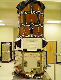
The Paz satellite, which is fitted with radar technology and a very high resolution, was ordered from Hisdesat by the Ministry of Defence at the end of 2007 under the National Earth Observation Plan to meet the operational requirements of the Spanish Armed Forces. In turn, Hisdesat contracted the design and manufacture of the satellite to EADS CASA Espacio, meaning this is the first time that the Spanish space industry has undertaken the challenge to build a satellite of this size and complexity to be assembled and manufactured entirely in Spain.


Carme Chacón explained that the radar technology installed on this satellite, 100% designed and manufactured in Spain, will enable up to 100 images of the Earth's surface to be taken per day at a resolution of up to one metre. In three years' time, this capacity will be joined by that of the Ingeniosatellite and its optical technology. "With the Paz and Ingenio satellites, our military will have their own observation systems, thus multiplying our autonomy in terms of obtaining information and better protecting the interests of Spain", she said.


The presentation ceremony for the Paz satellite, which took place on the premises of EADS CASA Espacio, was attended by the Minister for Defence, Carme Chacón, the Chief of Defence Staff, Jose Julio Rodríguez, the State Secretary for Defence, Constantino Méndez, the Secretary-General for Industry, Teresa Santero, the Managing Director of Hisdesat, Roberto López, and the General Director of Astrium España, Antonio Cuadrado.


Carme Chacón stressed that this satellite, which will be in orbit in 2013, will be able to detect the position of any ship in the world that could possibly become the victim of hijacking thanks to the automatic AIS identification system. Furthermore, it will enable the tasks of border control monitoring, the verification of international treaties, the monitoring and assessment of natural disasters and environmental control to be carried out more easily and effectively.


The Minister for Defence also mentioned the innovation and efforts being made by the Spanish aerospace industry, which has positioned itself among the top five European powers in this field in only a few years, progressing at the same pace as the Spanish Armed Forces. "The Pazsatellite will multiply the operational capabilities of our Armed Forces both within and beyond our borders", she said.


One of the greatest challenges for the Spanish space industry


For his part, the Managing Director of Hisdesat, Roberto López, said that the presentation of the Paz satellite represents a successful response to one of the greatest challenges for the Spanish space industry in recent years. "Thanks to the support from the Ministry of Defence and the Ministry of Industry, Tourism and Trade, we have travelled the long and arduous path to creating asatellite fitted with sophisticated technology that will enable our country to play a very important role in the field of high-resolutionsatellite imaging", he said.


Finally, the General Director of Astrium España, Antonio Cuadrado, highlighted that the Paz satellite will give Spain the ability to observe the Earth at any time, day or night, and in any meteorological conditions. "This programme forms part of the National Earth Observation Plan and consolidates Astrium España as the leading and integrating satellite contractor in our country", he concluded.


Hisdesat has contracted the launch of the satellite with the Russian Dnepr launcher, scheduled for some time at the end of 2012. The satellite, which has been designed for a five and a half year mission, measures 5 metres in height and 2.4 metres in diameter, with a total weight of some 1,400 kilograms.


From manufacture to launch, the Paz satellite will generate 425 highly-qualified jobs in Spain and another 80 jobs once it is in orbit.


The National Institute for Aerospace Technology (Spanish acronym: INTA) is responsible for developing the terrestrial aspects of theprogramme, which include control and monitoring stations in Torrejón ( Madrid) and Maspalomas (Gran Canaria), as well as the data processing and storage centres.

Partager cet article
Repost0
9 juin 2011 4 09 /06 /juin /2011 11:45

http://www.aviationweek.com/media/images/defense_images/Rockets/deltaIVHeavyNight-USAF.jpg


Jun 8, 2011 By Irene Klotz aerospace daily and defense report


CAPE CANAVERAL, Fla. — The U.S. Air Force plans to fold operations, maintenance, systems engineering and sustainment work at the Eastern and Western Test Ranges and the Space and Missile Systems Center into a single contract, estimated to be worth about $3.8 billion over 10 years.


The draft request for proposals for the U.S. Air Force Launch & Test Range Systems Integrated Support Contract, or LISC, is expected to be released this month. Boeing on June 7 formally announced its entry into the competition. Other LISC contenders are expected to include a team led by Raytheon and a joint venture called InSpace21 backed by CSC and Honeywell. The Air Force is expected to make its LISC contract award in early 2012.


LISC is intended to consolidate three contracts — the Spacelift Range System contract, currently held by ITT; the Western Range Operations Communications and Information contract, held by InDyne; and the Eastern Range Technical Services contract, held by a joint CSC-Raytheon partnership known as Computer Sciences Raytheon.


The Air Force is looking to LISC as a way to become more efficient and cut costs, even in the face of increased demand for launch support services as new commercial operators, such as Space Exploration Technologies, ramp up production.


“Ten years ago, the idea of consolidation of range support activities was a major stretch,” says retired Brig. Gen. Greg Pavlovich, a former commander of the 45th Space Wing who is now Boeing’s general manager for the LISC program.


The goal of LISC, Pavlovich says, is to support the launch vehicle and payload communities by sustaining and operating “a diverse collection of distributed systems that provide for the safe and effective launch, testing and tracking of Department of Defense, civil and commercial spacelift vehicles, in addition to conducting ballistic missile, guided weapon and aeronautical tests and evaluations.” Boeing intends to do so by providing “rigorous life-cycle management for sustainable and affordable mission support,” Pavlovich says.


“There [are] various generations of technologies, some quite dated, some that are relatively new, and the idea is to bring that into one legacy system that meets the same capability,” says Art Glaab, Boeing’s LISC capture team leader. “Some systems may be requiring retirement. ... There may be some modernization, but the idea is to bring it into a lifecycle perspective, knowing which systems [to] retire, which systems [to] replace — at the right time — is the capability [the Air Force] is looking for.”


One area that is not expected to be significantly cut is the payroll. ITT, InDyne and Computer Sciences Raytheon currently employ about 2,500 people under their existing range support contracts.


“The [Air Force] early on recognized that they needed to re-evaluate their business practices and modify processes to improve efficiencies,” Glaab says. “They are translating that efficiency improvement as not being a reduction of skills. The customer has been very clear to us they don’t want to see a contractor come in to reduce skills, to eliminate jobs, but they do see the ability to do process consolidation. That should drive some capability improvements.”

Partager cet article
Repost0
7 juin 2011 2 07 /06 /juin /2011 18:00

http://www.thalesgroup.com/Resizer.ashx?i=/uploadedImages/Signposts/External_Signposts/Countries/Spain/TAS45112tas.jpg&w=230

07 June 2011 Thales Alenia Space

Thales Alenia Space España is awarded contracts worth more than 11 million Euros for the European Earth Observation MUSIS program.

The Spanish Company leads the national market in optical observation instruments and is at the foremost position in technology for observation and science missions.

Thales Alenia Space España has been awarded important contracts summing up to a value of more than 7.5 million Euros. These contracts are for the MUSIS program for Earth observation. The company will be entrusted with the design, development, manufacturing, qualification, supply of electronics for the focal plane of the optical instrument (FPPB), and the service module (MSI) for the two first high optical resolution CSO satellites of the European MUSIS program, while having the option of a third one.

The CSO (Optical Space Component) is the French government contribution to the future MUSIS (Multinational Space-based Imaging System) constellation, that will include optical and radar space components. The CSO satellites realization contract has been awarded end 2010 to Astrium by CNES, who was acting as delegate contracting authority on behalf the DGA (Direction Générale de l'Armement). These satellites will replace the current Helios 2 observational system..  Thales Alenia Space France is responsible for the Optical Payload (Instrument) and also will deliver to Astrium, the Solar Arrays, the X-band downlink sub-system and the Encryption Unit."

The Multinational Space-Based Imaging System (MUSIS) is a multinational program carried out by various European countries. The objective is to construct a common space infrastructure by combining national and/or bilateral programs, allowing the collaboration of these nations and providing them with the next-generation of European satellite intelligence systems, substituting their current national platforms. Through this, the contributing countries will reinforce their capacities and autonomy in the issue of surveillance, observation and reconnaissance.

Within the Thales Group, Thales Alenia Space España is considered to be a competence centre with regard to optical payloads of medium resolution (between 5 and 10 meters) used for scientific and Earth observation. The company uses a pioneer optical detection laboratory for the design, development and integration of subsystems for optical detection, allowing precise characterization of image sensor, integration and detection systems tests. Similarly, Thales Alenia Space España is extremely active in various projects, such as the national (Spanish) program of Earth observation INGENIO, the SENTINEL satellites for Europe's Global Monitoring for Environment and Security (GMES) programme, and is currently working on a civil and military satellite for a member state of the NATO, developing the high resolution electronic proximity for optical observation; all adding up to contracts worth more than 30 million Euros.

Juan Garcés de Marcilla, President and CEO of Thales Alenia Space España said: “I am extremely satisfied with the awarding of this contract, it recognizes our ability and leadership in payloads for optical observation, as well as showing the trust which our clients have in our company.” Garcés de Marcilla also said to “feel proud of the excellent competitive development in the exterior market, as it is the competition which allows us to strengthen our collaboration with the largest European space companies, consolidating and placing us at the forefront of the Spanish market in terms of technology for missions of observation and science.”

Partager cet article
Repost0
7 juin 2011 2 07 /06 /juin /2011 17:10

http://upload.wikimedia.org/wikipedia/commons/thumb/d/df/SPYDER.jpg/800px-SPYDER.jpg

TEL AVIV, Israel, June 6 (UPI)

Israel's High-Tech Industry Association has signed a memorandum of understanding with its Indian counterpart to boost cooperation in advanced technology, a move that will undoubtedly increase the Jewish state's burgeoning defense sales to India.

The Jerusalem Post reports that industry executives see the accord with the Confederation of Indian Industry, signed June 1, leading to a convergence of "Israel's innovative prowess with India's huge and talented pool of human resources."

Trade between Israel and India -- one Jewish, one Hindu, both locked in conflict with Islamist terror groups -- hit $47 billion in 2010, with India moving into second place among the Jewish state's export markets.

That didn't include defense sales on more than $1 billion annually. India is engaged in a top-to-bottom upgrade and expansion of its armed forces.

This includes massive spending on combat aircraft and building up naval forces to project Indian power across the Indian Ocean, a vital energy and trade route between the Middle East and Asia.

"Increased arms spending has created a natural market for Israeli military technology such as unmanned aerial vehicles and airborne early warning radar systems," the Post said.

In recent years, Israel has consolidated defense links with India into a strategic relationship.

On April 20, 2009, India launched its 650-pound RISAT-2 satellite, built by state-owned Israel Aerospace Industries and carrying the same multi-spectral aperture radar as the Tecstar-1 satellite developed for Israel's military.

The Indians, with Israeli help, fast-tracked vital surveillance systems in the wake of the attack by Islamic extremists on Mumbai, India's commercial hub, in November 2008 in which 166 people were killed, five of them Israelis.

In January 2009, India took delivery of the first of three Phalcon all-weather AWACS, also built by IAI, the flagship of Israel's defense industry, under a $1.1 billion deal. The radar system, produced by Israel's Elta Industries, is built around the Russian-built Ilyushin Il-76 aircraft. Delivery was advanced by two months following the carnage in Mumbai.

The Phalcons made India the first state in South Asia to have advanced multi-sensor AWACs capable of providing tactical surveillance or multiple airborne and surface targets and able to gather signals intelligence.

As part of the Phalcon deal, the Israelis disclosed they would establish five factories in India to produce artillery shells, a project reportedly worth $250 million.

Ties like this will likely deepen through the high-tech accord because of an Indian requirement that local components account for 30 percent of any contract.

Israeli firms generally focus on developing cutting-edge software and worldwide exports in 2010 totaled around $29 billion.

Given the fast-growing markets emerging in India and China, the high-tech accord is tailor-made for Israel's export-heavy economy. The two countries are already discussing an agreement to remove trade barriers.

The Israelis are focusing on the Indian state of Andhra Pradesh, home of the fast-growing software center at Hyderabad.

It is close to signing an agreement with Matimop of Israel, a government agency that facilitates multinational research and development projects.

Andhra Pradesh is becoming a high-tech industries powerhouse, with software exports of $8 billion in 2010.

Missiles are a key Israel-India connection, and that requires intensive high-tech cooperation.

In 2008, India signed a $4.1 billion deal to purchase a shore-based and seaborne anti-missile air-defense system based on Israel's Barak long-range naval weapon built by IAI.

In August that year, New Delhi signed a $2.5 billion contract with IAI and Israel's Rafael armaments company to jointly develop an advanced version of the Spyder surface-to-air missile.

Partager cet article
Repost0
6 juin 2011 1 06 /06 /juin /2011 11:55

http://www.spacedaily.com/images-lg/glonass-satellite-artwork-lg.jpg


Jun 06, 2011Moscow (XNA)


Russian Space Agency Roscosmos plans to launch five Glonass-M satellites and one Glonass-K satellite in 2011, Roscosmos' deputy chief Anatoly Shilov said Wednesday.


The first launch of the Glonass-M satellite is scheduled for August and the second is slated for October, Shilov said at a navigation forum here.


The Glonass-K new generation navigation satellite is expected to be launched in December, he added.


"Besides, we are still hoping to carry out a group launch of three Glonass-M satellites atop a Proton-M carrier rocket from Baikonur by the end of the year," he was quoted by Interfax news agency as saying.


The date of the group launch has yet to be determined, he said.


Last December a Proton-M carrier rocket, which lifted off from the Baikonur Cosmodrome in Kazakhstan, failed to deliver three Glonass-M navigation satellites to the orbit. The satellites fell into the Pacific Ocean. Investigators later blamed ground crew who had pumped too much fuel into a booster rocket.


Glonass is the Russian equivalent of the U.S. Global Positioning System (GPS), which is designed for both military and civilian use. The system requires 24 operational and 2-3 reserve satellites in orbit to ensure global coverage.

Partager cet article
Repost0
4 juin 2011 6 04 /06 /juin /2011 06:00

http://missiledefense.files.wordpress.com/2011/06/mda-logo.png?w=300&h=300


June 3rd, 2011 MDAA

John H. James, Director of the National Security Personnel System (NSPS) Transition Office, has been appointed the Executive Director of the Missile Defense Agency.  The appointment was effective May 23, 2011.


James was appointed NSPS Transition Office Director in January 2010, after the FY201 Defense Authorization Act repealed the NSPS.  His assignment was to direct three phases of the NSPS transition: 
1) close down the NSPS
2) transition former NSPS employees to other pay systems; and
3) design a new DoD-wide performance management and bonus distribution system for civilian employees.


James leaves the NSPS Transition Office after almost 90 percent (199,530) of the 226,000 former NSPS employees have been transitioned to General Schedule (GS) pay plans.  The remaining NSPS employees will transition before the end of 2011, as scheduled.


He set  in motion and directed the three design teams of union and management who are working to develop the personnel initiatives required in the FY2010 Defense Authorization Act: 
1) develop a fair, credible, and transparent enterprise performance appraisal system,
2) redesign procedures to streamline hiring flexibilities, and
3) establish a civilian workforce incentive fund to recognize performance and attract and retain employees with superior qualifications. 


“We have set the standard for an inclusive, broad-based design and development process, with the full support and participation of management and union,” James said.  Updates on the progress of these three design teams are available on the NSPS website.


Pat Tamburrino, Jr., Deputy Assistant Secretary of Defense for Civilian Personnel Policy, has been assigned to oversee the NSPS transition activities and lead the design teams’ work.

Partager cet article
Repost0
31 mai 2011 2 31 /05 /mai /2011 12:00


May 31, 2011 ASDNews Source : Sofradir


Paris, France - Sofradir, a leading developer and manufacturer of advanced infrared detectors for military, space and industrial applications, announced today that it has been awarded the contract to provide shortwave infrared (SWIR) arrays for the TROPOMI/S5 - (Sentinel 5 Precursor) mission, as part of the Global Monitoring for Environment and Security (GMES) space initiative. GMES is a joint undertaking of the European Commission and the European Space Agency (ESA).


Under the contract, Sofradir will deliver to SSTL (UK), a worldwide supplier of satellite and space equipment, off-the-shelf 1000x256 SWIR arrays, based on its Mercury Cadmium Telluride (MCT/HgCdTe) technology. Selecting an off-the-shelf model that has proven its performance and reliability has eliminated the need for Sofradir to go through a preliminary design phase, which can involve extensive screening and qualification. This translates into an 18-month saving in delivery time of the flight models. As a result, all deliveries will be completed within 24 months.


Related Research on ASDReports.com:

The Military Electro Optical Infrared (EO/IR) Systems Market 2010-2020: Airborne, Ground and Naval


"This new contract shows that Sofradir has the right infrared products for the space community," said Philippe Bensussan, chairman and CEO at Sofradir. "Repeat orders of our off-the-shelf space-qualified MCT detectors allow us to offer IR products to our space customers at affordable prices with short lead times and minimal risk."


The Sentinel-5-Precursor mission, scheduled for launch in 2014, is intended to fill a time gap between Envisat, an earlier generation of earth observation satellites for climate and environment monitoring, and Sentinel 5, which will be on-board the Post-EPS satellite scheduled for launch around 2019.


ESA funded the original development of the 1000x256 SWIR array for the Spectra mission in 1999. Since then, Sofradir has optimized the design of the focal plane array (FPA) and is presently offering two versions of packaging:


-- the FPA integrated in a dewar with an active cooler

-- the FPA in a hermetic package without cooling system, to be implemented with passive cooling in the satellite.


The SWIR with hermetic package without cooling system was selected because it offered some major advantages in reliability and power consumption. Unlike an active cooler that has moving mechanical parts that can shorten the overall life of the detector, passive cooling significantly increases reliability as it is dependent on the FPA only. Sofradir FPAs are known for their outstanding reliability in harsh environments. For example, Sofradir IR detectors aboard the spaceborne observation satellite Helios IIA have been operating continuously since the 2004 launch. The fully hermetic package with optimized thermal interface minimizes the cooling requirement. Other technological advances at Sofradir have enabled it to produce SWIR detectors that exhibit very high performance at relatively high temperatures (140K, -133oC), which means that they also consume less power.


Sofradir is increasingly being selected to participate in satellite and space missions for earth mapping, environment and disaster monitoring, meteorology and planet exploration. Its MCT IR detectors are in orbit in French military earth observation satellites, Helios IIA and IIB. Sofradir's IR detectors are also being used on ESA's Venus Express satellite (launched in 2005) and the French MoD SPIRALE satellites. All of the detectors are still exhibiting nominal performance. Other space activities include the Japanese space agency (JAXA) SGLI/G-COM (Second Generation GLI/Global Change Observation Mission), where Sofradir's IR detectors are in Flight Model Phase.


In 2010, Sofradir delivered 26 detectors for space programs. Development teams at Sofradir are also working on a 1000x1000 SWIR array partially funded by ESA. This detector has been earmarked as a candidate for several ESA-led projects in the future.

Partager cet article
Repost0
28 mai 2011 6 28 /05 /mai /2011 19:30

http://i.space.com/images/i/9834/i02/army-smdc-one-satellite.jpg?1306272842


Sat, May 28 2011 David Pugliese Defence Watch


Mike Wall of SPACE.com had a report about smallsat developments for the U.S. Army. He writes:


HUNTSVILLE, Ala. — The United States Army is making a serious push to launch swarms of tiny, inexpensive spy satellites, which would serve as eyes and ears for soldiers on the ground.


The move is an attempt to adapt to the changing nature of warfare, which increasingly requires small bands of American soldiers to hunt down elusive targets in rough, isolated terrain, such as the craggy hills of Afghanistan. The new satellites could help reduce the difficulty and danger of such operations.


Full story link here:


http://www.space.com/11771-military-space-army-tiny-spy-satellites.html

Partager cet article
Repost0
23 mai 2011 1 23 /05 /mai /2011 22:00

European Defence Agency


Brussels - 23 May 2011 EDA News


Following a negotiating mandate provided to the Head of the Agency, Ms. Catherine Ashton, by the EDA Steering Board in March 2010, the Council has today approved the Administrative Arrangement between the European Defence Agency and the European Space Agency concerning the establishment of their cooperation.


The Administrative arrangement will be signed by the European Defence Agency (EDA) and the European Space Agency (ESA) at the International Paris Air Show –Paris Le Bourget, on 20 June 2011.

The aim of the Arrangement is to provide a structured relationship and a mutually beneficial cooperation between EDA and ESA through the coordination of their respective activities. The cooperation will aim in particular at exploring the added value and contribution of space assets to the development of European capabilities in the area of crisis management and the Common Security and Defence Policy.


To date, EDA and ESA are cooperating on a variety of subjects, including Intelligence, Surveillance and Reconnaissance (ISR), Satellite Communication and satellite services for Unmanned Aerial systems (UAS) as well as research and technology.

Partager cet article
Repost0

Présentation

  • : RP Defense
  • : Web review defence industry - Revue du web industrie de défense - company information - news in France, Europe and elsewhere ...
  • Contact

Recherche

Articles Récents

Categories